| PID:
|
BBFM14 |
| Designation:
|
946 2450 G |
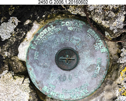
| Stamping:
|
2450 G 2006 |
| Stability:
|
Most reliable; expected to hold position well |
| Setting:
|
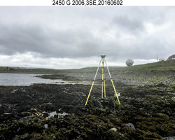
In rock outcrop or ledge |
| Description:
|
The bench mark is set flush near the SW corner of a lightly vegetated bedrock outcrop, on the east end of a point of land NW of the village of Nikolski, 206.70 m (678.1 ft) west of benchmark 946 2450 H, 149.1 m (489.2 ft) ESE of bench mark 946 2450 F, and 25.50 m (83.7 ft) slope distance east of the centerline of the road. |
| Observed:
|
2016-06-01T22:00:00Z |
| Source:
|
OPUS - page5 1209.04 |
|
|
|
| Close-up View
|
|
| REF_FRAME:
NAD_83(2011) |
EPOCH:
2010.0000 |
SOURCE:
NAVD88 (Computed using GEOID12B) |
UNITS:
m |
SET PROFILE
|
DETAILS
|
|
| LAT:
|
52° 56' 20.05221"
|
± 0.005
m |
| LON:
|
-168° 52' 8.51124"
|
±
0.015
m |
| ELL HT:
|
14.553 |
±
0.005
m |
| X:
|
-3779652.141 |
±
0.007
m |
| Y:
|
-743660.080 |
±
0.015
m |
| Z:
|
5066460.374 |
±
0.005
m |
| ORTHO HT:
|
1.521 |
±
0.010
m |
|
|
UTM
2 |
SPC
5010(AK10) |
| NORTHING:
|
5867599.575m |
239490.089m |
| EASTING:
|
643202.913m |
1478571.388m |
| CONVERGENCE:
|
1.70078599°
|
5.68282894°
|
| POINT SCALE:
|
0.99985170 |
0.99984963 |
| COMBINED FACTOR:
|
0.99984942 |
0.99984735 |
|
|
|
|
| Horizon View
|
|
|
|
|