| PID:
|
BBFM13 |
| Designation:
|
946 2450 H |
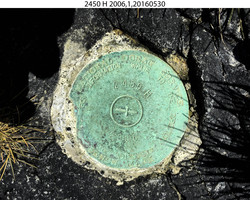
| Stamping:
|
2450 H 2006 |
| Stability:
|
Monument will probably hold position well |
| Setting:
|
In rock outcrop or ledge |
| Description:
|
The bench mark is set flush in a rock outcrop, 206.70 m (678.1 ft) east of benchmark 946 2450 G, 140.1 m (459.6 ft) WNW of bench mark 946 2450 ASTRO RM 2, 35.00 m (114.8 ft) north of the NE corner of an old multi-colored pole barn, and 11.20 m (36.7 ft) NE of the NE edge of a 0.75 m x 0.60 m x 0.20 m (2.5 ft x 2.0 ft x 0.7 ft) high concrete block just below the debris line which supports the NE side of two wooden rails. |
| Observed:
|
2016-05-31T23:22:00Z |
| Source:
|
OPUS - page5 1209.04 |
|
|
|
| Close-up View
|
|
| REF_FRAME:
NAD_83(2011) |
EPOCH:
2010.0000 |
SOURCE:
NAVD88 (Computed using GEOID12B) |
UNITS:
m |
SET PROFILE
|
DETAILS
|
|
| LAT:
|
52° 56' 19.36863"
|
± 0.006
m |
| LON:
|
-168° 51' 57.50201"
|
±
0.007
m |
| ELL HT:
|
14.405 |
±
0.012
m |
| X:
|
-3779628.901 |
±
0.010
m |
| Y:
|
-743865.054 |
±
0.010
m |
| Z:
|
5066447.521 |
±
0.007
m |
| ORTHO HT:
|
1.371 |
±
0.021
m |
|
|
UTM
2 |
SPC
5010(AK10) |
| NORTHING:
|
5867584.562m |
239489.425m |
| EASTING:
|
643409.023m |
1478778.043m |
| CONVERGENCE:
|
1.70322333°
|
5.68526602°
|
| POINT SCALE:
|
0.99985242 |
0.99984963 |
| COMBINED FACTOR:
|
0.99985016 |
0.99984737 |
|
|
|
|
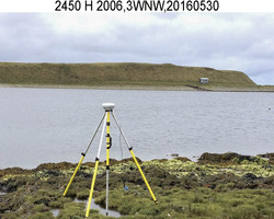
| Horizon View
|
|
|
|
|