| PID:
|
BBFL97 |
| Designation:
|
946 1710 F |
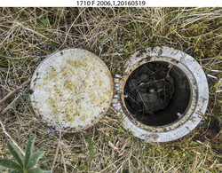
| Stamping:
|
1710 F 2006 |
| Stability:
|
Monument will probably hold position well |
| Setting:
|
Stainless steel rod without sleeve (10FT+ or 3.048M+) |
| Description:
|
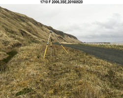
The station a stainless steel rod set 244 m (801 ft) WNW of bench mark 946 1710 G, 85 m (279 ft) WNW of bench mark 946 1710 E, 63 m (207 ft) east of the centerline of an ATV trail which runs between a cabin and shed and forms a chord with the main road which leads to the dock, 45 m (148 ft) NW of a 0.60 m (2.0 ft) diameter metal culvert on the south side of the road, and 2.99 m (9.8 ft) NNE of the north edge of the gravel road. |
| Observed:
|
2016-05-21T05:20:00Z |
| Source:
|
OPUS - page5 1209.04 |
|
|
|
| Close-up View
|
|
| REF_FRAME:
NAD_83(2011) |
EPOCH:
2010.0000 |
SOURCE:
NAVD88 (Computed using GEOID12B) |
UNITS:
m |
SET PROFILE
|
DETAILS
|
|
| LAT:
|
52° 14' 5.60028"
|
± 0.006
m |
| LON:
|
-174° 10' 32.25030"
|
±
0.007
m |
| ELL HT:
|
13.842 |
±
0.013
m |
| X:
|
-3894133.286 |
±
0.012
m |
| Y:
|
-397225.452 |
±
0.008
m |
| Z:
|
5018862.953 |
±
0.010
m |
| ORTHO HT:
|
5.617 |
±
0.023
m |
|
|
UTM
1 |
SPC
5010(AK10) |
| NORTHING:
|
5790922.833m |
138987.410m |
| EASTING:
|
692858.941m |
1124612.141m |
| CONVERGENCE:
|
2.23343118°
|
1.45388522°
|
| POINT SCALE:
|
1.00005661 |
0.99990292 |
| COMBINED FACTOR:
|
1.00005444 |
0.99990075 |
|
|
|
|
| Horizon View
|
|
|
|
|