| PID:
|
BBFL95 |
| Designation:
|
946 1710 B |
| Stamping:
|
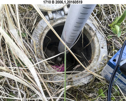
1710 B 2006 |
| Stability:
|
Monument will probably hold position well |
| Setting:
|
Stainless steel rod without sleeve (10FT+ or 3.048M+) |
| Description:
|
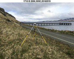
The station is set at the base of the bluff, 151 m (495 ft) NW of bench mark 946 1710 D, 144 m (472 ft) ESE of bench mark 946 1710 E, 13.30 m (46.3 ft) SE of a "Speed Limit 20" sign on the NE side of the road, and 2.41 m (7.9 ft) NE of the north edge of a single lane gravel road which ends at the dock. |
| Observed:
|
2016-05-20T05:13:00Z |
| Source:
|
OPUS - page5 1209.04 |
|
|
|
| Close-up View
|
|
| REF_FRAME:
NAD_83(2011) |
EPOCH:
2010.0000 |
SOURCE:
NAVD88 (Computed using GEOID12B) |
UNITS:
m |
SET PROFILE
|
DETAILS
|
|
| LAT:
|
52° 14' 1.43321"
|
± 0.011
m |
| LON:
|
-174° 10' 22.27158"
|
±
0.015
m |
| ELL HT:
|
14.754 |
±
0.006
m |
| X:
|
-3894215.913 |
±
0.014
m |
| Y:
|
-397424.237 |
±
0.014
m |
| Z:
|
5018784.793 |
±
0.002
m |
| ORTHO HT:
|
6.531 |
±
0.013
m |
|
|
UTM
1 |
SPC
5010(AK10) |
| NORTHING:
|
5790801.509m |
138863.472m |
| EASTING:
|
693053.201m |
1124804.703m |
| CONVERGENCE:
|
2.23558948°
|
1.45609418°
|
| POINT SCALE:
|
1.00005753 |
0.99990313 |
| COMBINED FACTOR:
|
1.00005522 |
0.99990082 |
|
|
|
|
| Horizon View
|
|
|
|
|