| PID:
|
BBFL94 |
| Designation:
|
946 1710 A |
| Stamping:
|
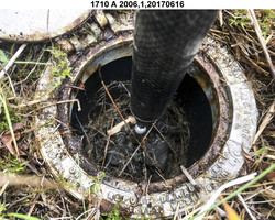
1710 A 2006 |
| Stability:
|
Monument will probably hold position well |
| Setting:
|
Stainless steel rod without sleeve (10FT+ or 3.048M+) |
| Mark Condition:
|
G |
| Description:
|
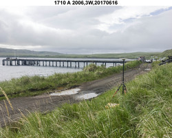
The station is set at the base of the bluff, 152 m (499 ft) ENE of bench mark 946 1710 C, 85.31 m (279.9 ft) ESE of bench mark 946 1710 D, 44.9 m (147.6 ft) SE of the southeasterly most of two 1.98 m (6.5 ft) high red blank diamond shaped street signs at the end of the road, 10.39 m (34.1 ft) NE of the edge of beach and grass line, and 5.00 m (16.4 ft) NE of the centerline of the ATV trail. |
| Observed:
|
2017-06-17T01:51:00Z |
more obs 2017-02-21
|
| Source:
|
OPUS - page5 1603.24 |
|
|
|
| Close-up View
|
|
| REF_FRAME:
NAD_83(2011) |
EPOCH:
2010.0000 |
SOURCE:
NAVD88 (Computed using GEOID12B) |
UNITS:
m |
SET PROFILE
|
DETAILS
|
|
| LAT:
|
52° 13' 56.26549"
|
± 0.010
m |
| LON:
|
-174° 10' 13.20744"
|
±
0.009
m |
| ELL HT:
|
13.456 |
±
0.017
m |
| X:
|
-3894323.267 |
±
0.018
m |
| Y:
|
-397608.109 |
±
0.010
m |
| Z:
|
5018685.941 |
±
0.007
m |
| ORTHO HT:
|
5.236 |
±
0.030
m |
|
|
UTM
1 |
SPC
5010(AK10) |
| NORTHING:
|
5790648.606m |
138708.185m |
| EASTING:
|
693231.333m |
1124980.711m |
| CONVERGENCE:
|
2.23753830°
|
1.45810068°
|
| POINT SCALE:
|
1.00005837 |
0.99990339 |
| COMBINED FACTOR:
|
1.00005626 |
0.99990128 |
|
|
|
|
| Horizon View
|
|
|
|
|