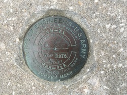
| PID:
|
BBFL22 |
| Designation:
|
CH 71 |
| Stamping:
|
CH-71 JAX-FLA 1975 |
| Stability:
|
Monument will probably hold position well |
| Setting:
|
Retaining wall or concrete ledge |
| Description:
|
Mark is located at Trident Pier at Cape Canaveral, FL. YOU WILL NEED TO CONTACT SECURITY TO GET ACCESS TO BASE. Mark is Army Corps of Engineers disk, located at the NW corner of retaining wall at the NE corner of pier. Mark is 48.8 feet north of the south end of retaining wall, 46.6 feet west of the east end of retaining wall, 42.9 feet NW of the center of round washing area and 6.7 feet east of the northern bollard located west of corner of retaining wall. |
| Observed:
|
2017-01-13T17:53:00Z |
| Source:
|
OPUS - page5 1209.04 |
|
|
|
| Close-up View
|
|
| REF_FRAME:
NAD_83(2011) |
EPOCH:
2010.0000 |
SOURCE:
NAVD88 (Computed using GEOID18) |
UNITS:
m |
SET PROFILE
|
DETAILS
|
|
| LAT:
|
28° 25' 9.65240"
|
± 0.010
m |
| LON:
|
-80° 35' 35.46695"
|
±
0.010
m |
| ELL HT:
|
-25.188 |
±
0.011
m |
| X:
|
917526.556 |
±
0.008
m |
| Y:
|
-5538240.526 |
±
0.008
m |
| Z:
|
3017446.591 |
±
0.013
m |
| ORTHO HT:
|
3.058 |
±
0.053
m |
|
|
UTM
17 |
SPC
901(FL E) |
| NORTHING:
|
3143724.426m |
452746.920m |
| EASTING:
|
539843.321m |
239856.920m |
| CONVERGENCE:
|
0.19361432°
|
0.19361432°
|
| POINT SCALE:
|
0.99961959 |
0.99996077 |
| COMBINED FACTOR:
|
0.99962354 |
0.99996473 |
|
|
|
|
| Horizon View
|
|
|
|
|