| PID:
|
BBFH53 |
| Designation:
|
945 5920 D |
| Stamping:
|
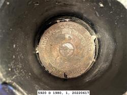
5920 D 1980 |
| Stability:
|
Monument will probably hold position well |
| Setting:
|
A metal rod driven into ground. Describe below. |
| Mark Condition:
|
G |
| Description:
|
THE MARK IS 46.88 M (153.8 FT) EAST OF A FIRE PLUG, 19.08 M (62.6 FT) NORTHEAST OF A STEEL LIGHT POLE, 10.76 M (35.3 FT) SOUTH OF THE CENTER OF A TRAFFIC ISLAND OF LOOP ROAD, 2.32 M (7.6 FT) NORTH OF A CYCLONE FENCE, 1.40 M (4.6 FT) EAST OF THE WESTERN END OF A STEEL GUARD RAIL, 0.79 M (2.6 FT) NORTH OF A WITNESS POST AND ENCASED IN A 4-IN (10 CM) PVC PIPE WITH A LID. |
| Observed:
|
2022-06-17T17:57:00Z |
more obs 2016-09-19
|
| Source:
|
OPUS - page5 2008.25 |
|
|
|
| Close-up View
|
|
| REF_FRAME:
NAD_83(2011) |
EPOCH:
2010.0000 |
SOURCE:
NAVD88 (Computed using GEOID12B) |
UNITS:
m |
SET PROFILE
|
DETAILS
|
|
| LAT:
|
61° 13' 36.02168"
|
± 0.012
m |
| LON:
|
-149° 53' 20.24570"
|
±
0.011
m |
| ELL HT:
|
16.968 |
±
0.023
m |
| X:
|
-2662658.129 |
±
0.011
m |
| Y:
|
-1544174.638 |
±
0.016
m |
| Z:
|
5567559.247 |
±
0.020
m |
| ORTHO HT:
|
10.391 |
±
0.084
m |
|
|
UTM
6 |
SPC
5004(AK 4) |
| NORTHING:
|
6791464.134m |
804760.465m |
| EASTING:
|
344898.275m |
505964.789m |
| CONVERGENCE:
|
-2.53275833°
|
0.09733333°
|
| POINT SCALE:
|
0.99989474 |
0.99990044 |
| COMBINED FACTOR:
|
0.99989208 |
0.99989778 |
|
|
|
|
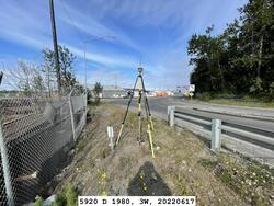
| Horizon View
|
|
|
|
|