| PID:
|
BBFH22 |
| Designation:
|
944 0079 E |
| Stamping:
|
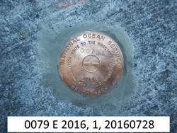
0079 E 2016 |
| Stability:
|
Monument will probably hold position well |
| Setting:
|
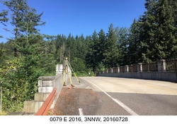
Abutment or pier of large bridges |
| Description:
|
The bench mark is a disk set in the sidewalk on the SW abutment of the Doetsch Ranch Road bridge over railroad tracks in Beacon Rock State Park, 52.15 m (171.1 ft) SE of the north end of the concrete sidewalk, 5.82 m (19.1 ft) SW of the road center line, 5.05 m (16.6 ft) NW of the SE end of the concrete bridge railing, 1.55 m (5.1 ft) SW of the NE edge of sidewalk along the road, and 0.12 m (0.4 ft) above road level. |
| Observed:
|
2016-07-28T16:53:00Z |
| Source:
|
OPUS - page5 1209.04 |
|
|
|
| Close-up View
|
|
| REF_FRAME:
NAD_83(2011) |
EPOCH:
2010.0000 |
SOURCE:
NAVD88 (Computed using GEOID18) |
UNITS:
m |
SET PROFILE
|
DETAILS
|
|
| LAT:
|
45° 37' 9.45188"
|
± 0.001
m |
| LON:
|
-122° 1' 47.26051"
|
±
0.009
m |
| ELL HT:
|
5.378 |
±
0.013
m |
| X:
|
-2370001.844 |
±
0.013
m |
| Y:
|
-3788410.652 |
±
0.008
m |
| Z:
|
4535756.174 |
±
0.009
m |
| ORTHO HT:
|
27.350 |
±
0.055
m |
|
|
UTM
10 |
SPC
4602(WA S) |
| NORTHING:
|
5052207.384m |
32942.038m |
| EASTING:
|
575638.742m |
380687.839m |
| CONVERGENCE:
|
0.69344653°
|
-1.11123634°
|
| POINT SCALE:
|
0.99967034 |
1.00005538 |
| COMBINED FACTOR:
|
0.99966950 |
1.00005454 |
|
|
|
|
| Horizon View
|
|
|
|
|