| PID:
|
BBFH02 |
| Designation:
|
863 7689 B |
| Stamping:
|
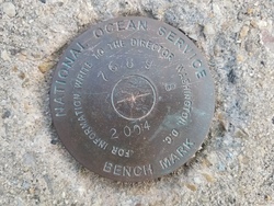
7689 B 2004 |
| Stability:
|
May hold, commonly subject to ground movement |
| Setting:
|
Massive structures (other than listed below) |
| Mark Condition:
|
G |
| Description:
|
The bench mark is a disk set in the top of a concrete bulkhead located west of the concrete pier at the US Coast Guard Training Center Yorktown, 49.21 m (161.4 ft) west of the centerline of the Coast Guard pier, 32.44 m (106.4 ft) north of the NW corner of a small cinderblock building NO. 178, 3.21 m (10.5 ft) east of the west end of the bulkhead, and 0.35 m (1.15 ft) south of the north face of the bulkhead. |
| Observed:
|
2020-09-16T11:38:00Z |
more obs 2020-10-06
|
| Source:
|
OPUS - page5 2008.25 |
|
|
|
| Close-up View
|
|