| PID:
|
BBFG95 |
| Designation:
|
944 0483 B |
| Stamping:
|
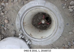
0483 B 2016 |
| Stability:
|
Monument will probably hold position well |
| Setting:
|
Stainless steel rod in sleeve (10FT+ or 3.048M+) |
| Description:
|
The station is a stainless steel rod with sleeve driven 15.2 m (49.9 ft) to refusal, encased in a NOS logo cover with kickblock at the residence of 273 Barlow Point Rd, 49.72 m (163.1 ft) east of the SE corner of a solar farm, 33.65 m (110.4 ft) WSW of the end fence post at the eastern corner of the lot, 19.45 m (63.8 ft) west of a fence post at the intersection of two fences, and 5.75 m (18.9 ft) WSW of the centerline of the gravel driveway. The datum point is set 4 cm (2 in) below grade. |
| Observed:
|
2016-07-23T00:47:00Z |
| Source:
|
OPUS - page5 1209.04 |
|
|
|
| Close-up View
|
|
| REF_FRAME:
NAD_83(2011) |
EPOCH:
2010.0000 |
SOURCE:
NAVD88 (Computed using GEOID18) |
UNITS:
m |
SET PROFILE
|
DETAILS
|
|
| LAT:
|
46° 9' 13.20630"
|
± 0.008
m |
| LON:
|
-123° 2' 3.90435"
|
±
0.013
m |
| ELL HT:
|
-19.149 |
±
0.008
m |
| X:
|
-2412803.978 |
±
0.008
m |
| Y:
|
-3710510.685 |
±
0.016
m |
| Z:
|
4577082.475 |
±
0.003
m |
| ORTHO HT:
|
2.066 |
±
0.048
m |
|
|
UTM
10 |
SPC
4602(WA S) |
| NORTHING:
|
5111121.913m |
94324.836m |
| EASTING:
|
497342.332m |
304264.715m |
| CONVERGENCE:
|
-0.02482218°
|
-1.84099046°
|
| POINT SCALE:
|
0.99960009 |
0.99994278 |
| COMBINED FACTOR:
|
0.99960309 |
0.99994578 |
|
|
|
|
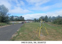
| Horizon View
|
|
|
|
|