| PID:
|
BBFG53 |
| Designation:
|
946 5953 A |
| Stamping:
|
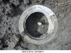
5953 A 2016 |
| Stability:
|
Monument will probably hold position well |
| Setting:
|
Stainless steel rod in sleeve (10FT+ or 3.048M+) |
| Description:
|
The bench mark is a stainless steel rod in a sleeve, encased in a 7-in NOS logo cap, driven 24.38 m (80.0 ft), it is 201 m (659.4 ft) north of the northwest corner of a 4-acre lake orientated north to south about 300 m (1000 ft) from the shoreline, 65.05 m (213.4 ft) north of bench mark 9465953 B, 37.55 m (123.2 ft) SE of the tundra shoreline cliff, and 5.55 m (18.2 ft) west of a winter trail. The datum point is set 4.0 cm (2 inches) below ground. |
| Observed:
|
2016-06-11T00:23:00Z |
| Source:
|
OPUS - page5 1209.04 |
|
|
|
| Close-up View
|
|
| REF_FRAME:
NAD_83(2011) |
EPOCH:
2010.0000 |
SOURCE:
NAVD88 (Computed using GEOID12B) |
UNITS:
m |
SET PROFILE
|
DETAILS
|
|
| LAT:
|
59° 56' 49.70460"
|
± 0.015
m |
| LON:
|
-164° 12' 34.87115"
|
±
0.007
m |
| ELL HT:
|
13.255 |
±
0.014
m |
| X:
|
-3081371.510 |
±
0.008
m |
| Y:
|
-871377.625 |
±
0.007
m |
| Z:
|
5497541.649 |
±
0.019
m |
| ORTHO HT:
|
2.916 |
±
0.025
m |
|
|
UTM
3 |
SPC
5008(AK 8) |
| NORTHING:
|
6645787.908m |
663554.377m |
| EASTING:
|
544151.465m |
600040.708m |
| CONVERGENCE:
|
0.68407771°
|
1.54975764°
|
| POINT SCALE:
|
0.99962389 |
1.00002261 |
| COMBINED FACTOR:
|
0.99962182 |
1.00002054 |
|
|
|
|
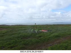
| Horizon View
|
|
|
|
|