| PID:
|
BBFG52 |
| Designation:
|
946 6012 A |
| Stamping:
|
6012 A 2016 |
| Stability:
|
Monument will probably hold position well |
| Setting:
|
Stainless steel rod in sleeve (10FT+ or 3.048M+) |
| Description:
|
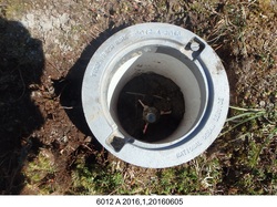
The bench mark is a stainless steel rod in a sleeve, encased in a 7-in NOS logo cap, driven 4.33 m (14.2 ft) to refusal, it is 125 m (410 ft) NNW of bench mark 9466012 B, 21.70 m (71.2 ft) SSW of the tundra shoreline cliff to the north, 21.54 m (70.7 ft) NNE of the tundra shoreline cliff to the south, and 1.00 m (3.3 ft) south of a tundra mound with a dead bush. The datum point is set 3.0 cm (1 inch) above ground. |
| Observed:
|
2016-06-06T03:10:00Z |
| Source:
|
OPUS - page5 1209.04 |
|
|
|
| Close-up View
|
|
| REF_FRAME:
NAD_83(2011) |
EPOCH:
2010.0000 |
SOURCE:
NAVD88 (Computed using GEOID12B) |
UNITS:
m |
SET PROFILE
|
DETAILS
|
|
| LAT:
|
60° 2' 36.80191"
|
± 0.013
m |
| LON:
|
-165° 40' 45.44640"
|
±
0.014
m |
| ELL HT:
|
17.013 |
±
0.007
m |
| X:
|
-3093694.376 |
±
0.010
m |
| Y:
|
-789763.774 |
±
0.016
m |
| Z:
|
5502916.626 |
±
0.005
m |
| ORTHO HT:
|
6.771 |
±
0.014
m |
|
|
UTM
3 |
SPC
5008(AK 8) |
| NORTHING:
|
6656456.293m |
672985.522m |
| EASTING:
|
462161.002m |
517870.219m |
| CONVERGENCE:
|
-0.58854791°
|
0.27786498°
|
| POINT SCALE:
|
0.99961755 |
0.99990391 |
| COMBINED FACTOR:
|
0.99961489 |
0.99990125 |
|
|
|
|
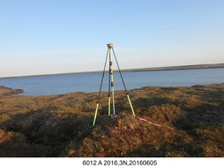
| Horizon View
|
|
|
|
|