| PID:
|
BBFG13 |
| Designation:
|
945 1054 TIDAL 2 |
| Stamping:
|
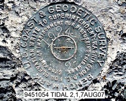
2 1924 |
| Stability:
|
Most reliable; expected to hold position well |
| Setting:
|
In rock outcrop or ledge |
| Mark Condition:
|
G |
| Description:
|
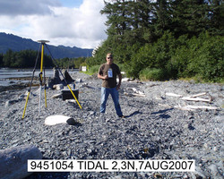
The station is set flush in the highest flat point of an exposed bedrock outcrop, 108.8 ft (33.17 m) south-southeast of tidal bench mark 945 1054 TIDAL 1, 85.2 ft (25.97 m) southeast of the south edge of the F/V SARAH MARIA memorial plaque, 63.9 ft (19.49 m) southwest of the center of the concrete pad supporting the "Earth scope" plate tectonic GPS station antenna, approximately 16 ft (5 m) west of the high water line and buried beneath approximately 1.6 ft (0.5 m) of shale. |
| Observed:
|
2007-08-06T17:21:00Z |
more obs 2016-06-20
|
| Source:
|
OPUS - page5 1209.04 |
|
|

|
| Close-up View
|
|
| REF_FRAME:
NAD_83(2011) |
EPOCH:
2010.0000 |
SOURCE:
NAVD88 (Computed using GEOID12B) |
UNITS:
m |
SET PROFILE
|
DETAILS
|
|
| LAT:
|
56° 14' 41.79003"
|
± 0.006
m |
| LON:
|
-134° 38' 49.93204"
|
±
0.011
m |
| ELL HT:
|
2.802 |
±
0.011
m |
| X:
|
-2496271.903 |
±
0.015
m |
| Y:
|
-2527204.163 |
±
0.001
m |
| Z:
|
5279646.945 |
±
0.007
m |
| ORTHO HT:
|
3.958 |
±
0.020
m |
|
|
UTM
8 |
SPC
5001(AK 1) |
| NORTHING:
|
6233397.442m |
491458.913m |
| EASTING:
|
521863.738m |
757890.826m |
| CONVERGENCE:
|
0.29332354°
|
-0.81672188°
|
| POINT SCALE:
|
0.99960586 |
1.00001970 |
| COMBINED FACTOR:
|
0.99960542 |
1.00001926 |
|
|
|

|
| Horizon View
|
|
|
|
|