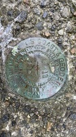
| PID:
|
BBFF94 |
| Designation:
|
945 0314 NO 11 |
| Stamping:
|
BM 11 1969 |
| Stability:
|
May hold, commonly subject to ground movement |
| Setting:
|
Footings of small/medium structures |
| Mark Condition:
|
G |
| Description:
|
NOAA description: The benchmark is a 3.5" USACE SBC set in the concrete pad of a green transformer box near the base of the breakwater for the Old Harbor on the eastern corner of the pad, 16.76 m (54.9 ft) west of a red fire hydrant at the base of the city dock, 2.27 m (7.4 ft) NW of the guardrail on the western side of the paved road to the city dock, 0.18 m (0.6 ft) SW of the NE edge of the concrete pad and 0.17 m (0.6 ft) NE of the SW edge of the concrete pad. |
| Observed:
|
2021-07-13T15:16:00Z |
more obs 2021-08-17
|
| Source:
|
OPUS - page5 2008.25 |
|
|
|
| Close-up View
|
|