| PID:
|
BBFF77 |
| Designation:
|
944 2705 A |
| Stamping:
|
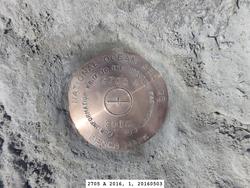
2705 A 2016 |
| Stability:
|
Most reliable; expected to hold position well |
| Setting:
|
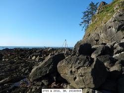
In rock outcrop or ledge |
| Description:
|
The bench mark is a disk set in a bedrock outcrop on the west side of Tskawahyah (Cannonball) Island, 69.58 m south of the spine of rocks at the NW corner of the island, 54.77 m NW of a rock cliff face below a grassy plateau on the south side of the island, 29.49 m south of a rock cliff below a pinnacle rock on the west side of the island, 16.34 m WSW of a ravine created by a rockslide at the SW corner of the island, 2.18 m east of the west edge of the outcrop, and 2.16 m above the stone beach. |
| Observed:
|
2016-05-05T21:49:00Z |
| Source:
|
OPUS - page5 1209.04 |
|
|
|
| Close-up View
|
|
| REF_FRAME:
NAD_83(2011) |
EPOCH:
2010.0000 |
SOURCE:
NAVD88 (Computed using GEOID18) |
UNITS:
m |
SET PROFILE
|
DETAILS
|
|
| LAT:
|
48° 10' 15.44979"
|
± 0.009
m |
| LON:
|
-124° 44' 10.21391"
|
±
0.002
m |
| ELL HT:
|
-19.668 |
±
0.001
m |
| X:
|
-2428229.693 |
±
0.003
m |
| Y:
|
-3502083.230 |
±
0.007
m |
| Z:
|
4729560.211 |
±
0.005
m |
| ORTHO HT:
|
2.926 |
±
0.067
m |
|
|
UTM
10 |
SPC
4601(WA N) |
| NORTHING:
|
5336759.276m |
137548.998m |
| EASTING:
|
370920.109m |
209854.002m |
| CONVERGENCE:
|
-1.29386444°
|
-2.90574162°
|
| POINT SCALE:
|
0.99980472 |
0.99994268 |
| COMBINED FACTOR:
|
0.99980780 |
0.99994576 |
|
|
|
|
| Horizon View
|
|
|
|
|