| PID:
|
BBFD96 |
| Designation:
|
944 0650 B |
| Stamping:
|
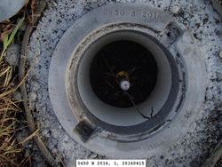
0650 B 2016 |
| Stability:
|
Monument will probably hold position well |
| Setting:
|
Stainless steel rod in sleeve (10FT+ or 3.048M+) |
| Description:
|
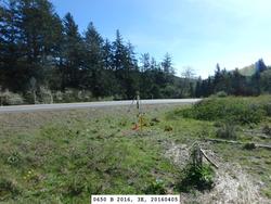
The bench mark is a flange encased rod set in a low grassy area along the west side of Highway 101, 146.3 m (480.0 ft) SE of south end of guardrail, 16.60 m (54.5 ft) SW of a traffic sign on east side of highway, 10.53 m (34.5 ft) SW of the centerline of highway, 4.30 m (14.1 ft) SW of the edge of pavement, and 0.20 m (0.7 ft) NE of a carsonite witness post. The datum point is set 5 cm (2 inches) below ground, being the top of a stainless steel rod driven 22.6 m (74.1 ft) to refusal. |
| Observed:
|
2016-04-06T18:20:00Z |
| Source:
|
OPUS - page5 1209.04 |
|
|
|
| Close-up View
|
|
| REF_FRAME:
NAD_83(2011) |
EPOCH:
2010.0000 |
SOURCE:
NAVD88 (Computed using GEOID18) |
UNITS:
m |
SET PROFILE
|
DETAILS
|
|
| LAT:
|
46° 22' 36.79726"
|
± 0.005
m |
| LON:
|
-123° 57' 5.47868"
|
±
0.003
m |
| ELL HT:
|
-20.036 |
±
0.016
m |
| X:
|
-2461871.596 |
±
0.003
m |
| Y:
|
-3656544.505 |
±
0.010
m |
| Z:
|
4594235.035 |
±
0.013
m |
| ORTHO HT:
|
3.722 |
±
0.051
m |
|
|
UTM
10 |
SPC
4602(WA S) |
| NORTHING:
|
5136363.612m |
121799.078m |
| EASTING:
|
426823.466m |
234560.509m |
| CONVERGENCE:
|
-0.68883104°
|
-2.50717092°
|
| POINT SCALE:
|
0.99966582 |
0.99992117 |
| COMBINED FACTOR:
|
0.99966896 |
0.99992431 |
|
|
|
|
| Horizon View
|
|
|
|
|