| PID:
|
BBFC43 |
| Designation:
|
872 0059 C |
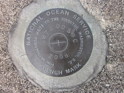
| Stamping:
|
872 0059 C 2008 |
| Stability:
|
Most reliable; expected to hold position well |
| Setting:
|
Pavement (street, sidewalk, curb, etc.) |
| Description:
|
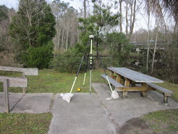
This mark is located at the Melton O. Nelson Memorial Park & Boat Ramp. The bench mark is a disk set flush with the concrete, 41.98 feet east southeast of Lofton Creek bulkhead on the
north side of the boat ramp, 28.74 foot northwest of a light pole No 1440707878402, 11.06 feet west of a 4.7 foot diameter Palm Tree, South of the North of two picnic benches. It is a standard National Ocean Service brass disk stamped 872 0059 C 2008. |
| Observed:
|
2016-02-22T13:40:00Z |
| Source:
|
OPUS - page5 1209.04 |
|
|
|
| Close-up View
|
|
| REF_FRAME:
NAD_83(2011) |
EPOCH:
2010.0000 |
SOURCE:
NAVD88 (Computed using GEOID18) |
UNITS:
m |
SET PROFILE
|
DETAILS
|
|
| LAT:
|
30° 37' 45.30573"
|
± 0.011
m |
| LON:
|
-81° 34' 14.80020"
|
±
0.006
m |
| ELL HT:
|
-27.446 |
±
0.020
m |
| X:
|
805208.885 |
±
0.005
m |
| Y:
|
-5433685.979 |
±
0.023
m |
| Z:
|
3230578.712 |
±
0.007
m |
| ORTHO HT:
|
0.970 |
±
0.058
m |
|
|
UTM
17 |
SPC
901(FL E) |
| NORTHING:
|
3388653.692m |
697759.783m |
| EASTING:
|
445299.978m |
145281.308m |
| CONVERGENCE:
|
-0.29080757°
|
-0.29080757°
|
| POINT SCALE:
|
0.99963691 |
0.99997810 |
| COMBINED FACTOR:
|
0.99964122 |
0.99998241 |
|
|
|
|
| Horizon View
|
|
|
|
|