| PID:
|
BBFC42 |
| Designation:
|
872 0059 E |
| Stamping:
|
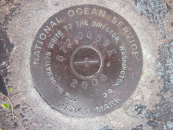
872 0059 E 2008 |
| Stability:
|
Most reliable; expected to hold position well |
| Setting:
|
Object surrounded by mass of concrete |
| Description:
|
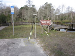
The mark is located at the Melton O. Nelson Memorial Park & Boat Ramp. The bench mark is a disk set flush with the concrete, 46.95 ft S of a light pole number 14407078402, 38.75 ft ESE of the Lofton Creek bulkhead on the S side of the ramp, 36.81 ft NNW of a 5.5 ft Diameter palm tree on the S side of the ramp, 9.8 ft W of bench mark 872 0059 A, 7.58 ft NE of a witness post. It is a standard National Ocean Service brass disk stamped 872 0059 E 2008. |
| Observed:
|
2016-02-22T13:52:00Z |
| Source:
|
OPUS - page5 1209.04 |
|
|

|
| Close-up View
|
|
| REF_FRAME:
NAD_83(2011) |
EPOCH:
2010.0000 |
SOURCE:
NAVD88 (Computed using GEOID18) |
UNITS:
m |
SET PROFILE
|
DETAILS
|
|
| LAT:
|
30° 37' 44.60248"
|
± 0.004
m |
| LON:
|
-81° 34' 14.63190"
|
±
0.014
m |
| ELL HT:
|
-27.471 |
±
0.038
m |
| X:
|
805214.933 |
±
0.019
m |
| Y:
|
-5433696.215 |
±
0.031
m |
| Z:
|
3230560.064 |
±
0.018
m |
| ORTHO HT:
|
0.945 |
±
0.067
m |
|
|
UTM
17 |
SPC
901(FL E) |
| NORTHING:
|
3388632.021m |
697738.105m |
| EASTING:
|
445304.349m |
145285.680m |
| CONVERGENCE:
|
-0.29078208°
|
-0.29078208°
|
| POINT SCALE:
|
0.99963690 |
0.99997809 |
| COMBINED FACTOR:
|
0.99964121 |
0.99998240 |
|
|
|

|
| Horizon View
|
|
|
|
|