| PID:
|
BBFB63 |
| Designation:
|
946 7551 B |
| Stamping:
|
7551 B 2011 |
| Stability:
|
Monument will probably hold position well |
| Setting:
|
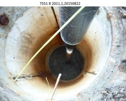
Stainless steel rod in sleeve (10FT+ or 3.048M+) |
| Description:
|
The bench mark is a metal rod set in the grass on the east side of boardwalk level with the ground that leads to the Yukon River, 65.75 m (215.7 ft) SW of bench mark 946 7551 C, 32.50 m (106.6 ft) NW of the centerline of an elevated boardwalk that runs WSW/ENE, 11.70 m (38.4 ft) NE of power pole # A-8, 2.30 m (7.5 ft) E of the centerline of the boardwalk that is level with the ground and runs north/south to the river, and 1.15 m (3.8 ft) NW of an orange Carsonite witness post. |
| Observed:
|
2015-08-22T17:45:00Z |
| Source:
|
OPUS - page5 1209.04 |
|
|
|
| Close-up View
|
|
| REF_FRAME:
NAD_83(2011) |
EPOCH:
2010.0000 |
SOURCE:
NAVD88 (Computed using GEOID12B) |
UNITS:
m |
SET PROFILE
|
DETAILS
|
|
| LAT:
|
62° 31' 57.20477"
|
± 0.018
m |
| LON:
|
-164° 50' 48.90910"
|
±
0.015
m |
| ELL HT:
|
10.067 |
±
0.019
m |
| X:
|
-2847110.872 |
±
0.021
m |
| Y:
|
-771039.872 |
±
0.014
m |
| Z:
|
5636144.943 |
±
0.019
m |
| ORTHO HT:
|
2.739 |
±
0.032
m |
|
|
UTM
3 |
SPC
5008(AK 8) |
| NORTHING:
|
6933519.150m |
950803.211m |
| EASTING:
|
507877.648m |
559353.910m |
| CONVERGENCE:
|
0.13582454°
|
1.02312705°
|
| POINT SCALE:
|
0.99960076 |
0.99994314 |
| COMBINED FACTOR:
|
0.99959919 |
0.99994156 |
|
|
|
|
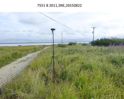
| Horizon View
|
|
|
|
|