| PID:
|
BBFB43 |
| Designation:
|
946 8863 J |
| Stamping:
|
8863 J 2012 |
| Stability:
|
Monument will probably hold position well |
| Setting:
|
In rock outcrop or ledge |
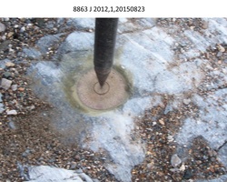
| Description:
|
The bench mark is a disk set on a 6.30 m x 2.75 m x 0.40 m (20.7 ft x 9.0 ft x 1.3 ft) high bedrock protrusion, 123.1 m (403.9 ft) NE of bench mark 946 8863 B RESET, 59.33 m (194.6 ft) ENE of bench mark 946 8863 H, 1.92 m (6.3 ft) north of an old drill hole, 0.61 m (2.0 ft) SSW of an iron pipe remains approximately 1 inch in diameter and cemented flush with the bedrock, and 0.31 m (1.0 ft) east of the bedrock's edge. |
| Observed:
|
2015-08-23T06:10:00Z |
| Source:
|
OPUS - page5 1209.04 |
|
|
|
| Close-up View
|
|
| REF_FRAME:
NAD_83(2011) |
EPOCH:
2010.0000 |
SOURCE:
NAVD88 (Computed using GEOID12B) |
UNITS:
m |
SET PROFILE
|
DETAILS
|
|
| LAT:
|
64° 36' 59.97183"
|
± 0.006
m |
| LON:
|
-162° 14' 59.06335"
|
±
0.019
m |
| ELL HT:
|
9.936 |
±
0.003
m |
| X:
|
-2611119.479 |
±
0.003
m |
| Y:
|
-835839.007 |
±
0.019
m |
| Z:
|
5739527.266 |
±
0.004
m |
| ORTHO HT:
|
3.644 |
±
0.008
m |
|
|
UTM
3 |
SPC
5007(AK 7) |
| NORTHING:
|
7168585.579m |
1182589.751m |
| EASTING:
|
631516.769m |
488051.040m |
| CONVERGENCE:
|
2.48510189°
|
-0.22563019°
|
| POINT SCALE:
|
0.99981178 |
0.99990175 |
| COMBINED FACTOR:
|
0.99981023 |
0.99990020 |
|
|
|
|
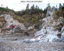
| Horizon View
|
|
|
|
|