| PID:
|
BBFB33 |
| Designation:
|
946 8691 E |
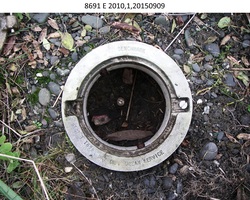
| Stamping:
|
8691 E 2010 |
| Stability:
|
Monument will probably hold position well |
| Setting:
|
Stainless steel rod without sleeve (10FT+ or 3.048M+) |
| Description:
|
The bench mark is set in a grassy shoal near the mouth of the Shaktoolik Lagoon, 73.25 m (240.3 ft) SE of benchmark 946 8691 D, 48.9 m (160.4 ft) of storm-debris gravel bar edge, 17.00 m (55.8 ft) SW of centerline of a dirt all terrain vehicle trail, and 0.85 m (2.8 ft) south of an orange carsonite witness post. |
| Observed:
|
2015-09-09T20:30:00Z |
| Source:
|
OPUS - page5 1209.04 |
|
|
|
| Close-up View
|
|
| REF_FRAME:
NAD_83(2011) |
EPOCH:
2010.0000 |
SOURCE:
NAVD88 (Computed using GEOID12B) |
UNITS:
m |
SET PROFILE
|
DETAILS
|
|
| LAT:
|
64° 22' 38.26521"
|
± 0.027
m |
| LON:
|
-161° 14' 6.73248"
|
±
0.008
m |
| ELL HT:
|
11.430 |
±
0.010
m |
| X:
|
-2618716.371 |
±
0.019
m |
| Y:
|
-889688.697 |
±
0.015
m |
| Z:
|
5728038.983 |
±
0.014
m |
| ORTHO HT:
|
4.207 |
±
0.019
m |
|
|
UTM
4 |
SPC
5007(AK 7) |
| NORTHING:
|
7140955.274m |
1156105.657m |
| EASTING:
|
392165.045m |
536913.023m |
| CONVERGENCE:
|
-2.01558822°
|
0.68959508°
|
| POINT SCALE:
|
0.99974238 |
0.99991668 |
| COMBINED FACTOR:
|
0.99974059 |
0.99991489 |
|
|
|
|
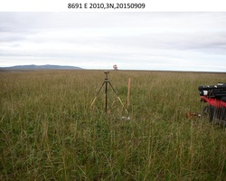
| Horizon View
|
|
|
|
|