| PID:
|
BBDY62 |
| Designation:
|
941 6841 S |
| Stamping:
|
6841 S 2007 |
| Stability:
|
Monument will probably hold position well |
| Setting:
|
Stainless steel rod in sleeve (10FT+ or 3.048M+) |
| Description:
|
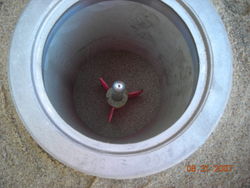
The benchmark is a flange-encased rod located 92.50 m (303.5 ft) east of PG&E light pole #64, 8.50 m (27.9 ft) south of the center line of Iverson Ave (Port Rd), 3.13 m (10.3 ft) SSW from an 8 inch diameter wooden post with reflectors, 0.50 m (1.6 ft) west from the east end of a stone wall, and 0.32 m (1.0 ft) north of the stone wall. The datum point of the mark is 10 cm (0.3 ft) below ground level, being the top of a 9/16 inch steel rod driven 9.75 m (32.0 ft) to refusal. |
| Observed:
|
2015-10-15T00:41:00Z |
| Source:
|
OPUS - page5 1209.04 |
|
|

|
| Close-up View
|
|