| PID:
|
BBDY54 |
| Designation:
|
944 1644 D |
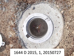
| Stamping:
|
1644 D 2015 |
| Stability:
|
Monument will probably hold position well |
| Setting:
|
Stainless steel rod in sleeve (10FT+ or 3.048M+) |
| Description:
|
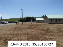
The mark is set in the grass NE of the Quinault Indian Nation Health Center building, 25.33 m (83.1 ft) north of the light pole east of the building, 24.90 m (81.7 ft) east of the light pole north of the building, 15.12 m (49.6 ft) ENE of a square storm drain, 11.22 m (36.8 ft) west of the top back of curb for the parking lot on the east side of the building, and 11.13 m (36.5 ft) south of the top back of curb for the parking lot on the north side of the building. |
| Observed:
|
2015-07-27T20:08:00Z |
| Source:
|
OPUS - page5 1209.04 |
|
|
|
| Close-up View
|
|
| REF_FRAME:
NAD_83(2011) |
EPOCH:
2010.0000 |
SOURCE:
NAVD88 (Computed using GEOID18) |
UNITS:
m |
SET PROFILE
|
DETAILS
|
|
| LAT:
|
47° 20' 22.83091"
|
± 0.005
m |
| LON:
|
-124° 16' 49.57177"
|
±
0.003
m |
| ELL HT:
|
14.745 |
±
0.019
m |
| X:
|
-2438848.173 |
±
0.005
m |
| Y:
|
-3577841.310 |
±
0.012
m |
| Z:
|
4667447.992 |
±
0.015
m |
| ORTHO HT:
|
38.987 |
±
0.052
m |
|
|
UTM
10 |
SPC
4602(WA S) |
| NORTHING:
|
5243706.991m |
229860.285m |
| EASTING:
|
403273.377m |
214411.376m |
| CONVERGENCE:
|
-0.94168527°
|
-2.74609321°
|
| POINT SCALE:
|
0.99971498 |
1.00000146 |
| COMBINED FACTOR:
|
0.99971267 |
0.99999915 |
|
|
|
|
| Horizon View
|
|
|
|
|