| PID:
|
BBDY51 |
| Designation:
|
944 9639 C |
| Stamping:
|
9639 C 2015 |
| Stability:
|
Monument will probably hold position well |
| Setting:
|
Stainless steel rod in sleeve (10FT+ or 3.048M+) |
| Description:
|
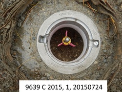
The mark is a flange encased rod set in the southern end of the lawn south of the marina building near the channel entrance, 61.01 m (200.2 ft) SSE of a fire hydrant along the rip rap channel shoreline, 51.70 m (169.6 ft) west of a fire hydrant along a dirt road, 17.80 m (58.4 ft) east of the edge of vegetation above the rip rap, and 14.90 m (48.9 ft) NNW of the drop down to the small embayment north of the eastern jetty. The datum point is set 4cm below grade, and encased in an NOS logo cover. |
| Observed:
|
2015-07-24T00:41:00Z |
| Source:
|
OPUS - page5 1209.04 |
|
|
|
| Close-up View
|
|
| REF_FRAME:
NAD_83(2011) |
EPOCH:
2010.0000 |
SOURCE:
NAVD88 (Computed using GEOID18) |
UNITS:
m |
SET PROFILE
|
DETAILS
|
|
| LAT:
|
48° 58' 31.88613"
|
± 0.006
m |
| LON:
|
-123° 3' 45.37142"
|
±
0.005
m |
| ELL HT:
|
-16.588 |
±
0.008
m |
| X:
|
-2288318.711 |
±
0.003
m |
| Y:
|
-3515287.029 |
±
0.003
m |
| Z:
|
4788760.020 |
±
0.010
m |
| ORTHO HT:
|
4.613 |
±
0.064
m |
|
|
UTM
10 |
SPC
4601(WA N) |
| NORTHING:
|
5424736.786m |
222021.088m |
| EASTING:
|
495418.803m |
336814.331m |
| CONVERGENCE:
|
-0.04722967°
|
-1.65973671°
|
| POINT SCALE:
|
0.99960026 |
1.00005458 |
| COMBINED FACTOR:
|
0.99960286 |
1.00005718 |
|
|
|
|
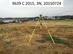
| Horizon View
|
|
|
|
|