| PID:
|
BBDY50 |
| Designation:
|
944 9746 A |
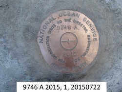
| Stamping:
|
9746 A 2015 |
| Stability:
|
Monument will probably hold position well |
| Setting:
|
Unspecified rock or boulder |
| Description:
|
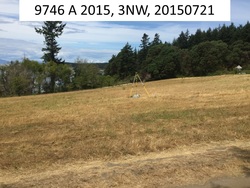
Bench mark disk set flush in the top of a buried 1.5m x 2m rock near the southern end of the first field along Waldron Center Road north of the dock in Cowlitz Bay, 60.17 m (197.4 ft) NNE of a large boulder at the corner of Waldron Center Road and the driveway, 50.15 m (164.5 ft) east of the centerline of Waldron Center Road, 14.36 m NW of the centerline of the driveway along the SE side of the field, 4.71 m (15.4 ft) WSW of the top of another buried boulder, and 0.30 m (1.0 ft) above ground. |
| Observed:
|
2015-07-21T20:00:00Z |
| Source:
|
OPUS - page5 1209.04 |
|
|
|
| Close-up View
|
|
| REF_FRAME:
NAD_83(2011) |
EPOCH:
2010.0000 |
SOURCE:
NAVD88 (Computed using GEOID18) |
UNITS:
m |
SET PROFILE
|
DETAILS
|
|
| LAT:
|
48° 41' 22.11075"
|
± 0.003
m |
| LON:
|
-123° 2' 7.77357"
|
±
0.007
m |
| ELL HT:
|
8.021 |
±
0.016
m |
| X:
|
-2299718.611 |
±
0.012
m |
| Y:
|
-3536458.129 |
±
0.007
m |
| Z:
|
4767838.937 |
±
0.010
m |
| ORTHO HT:
|
29.380 |
±
0.067
m |
|
|
UTM
10 |
SPC
4601(WA N) |
| NORTHING:
|
5392937.756m |
190165.825m |
| EASTING:
|
497387.878m |
337888.143m |
| CONVERGENCE:
|
-0.02666006°
|
-1.63955238°
|
| POINT SCALE:
|
0.99960008 |
0.99999205 |
| COMBINED FACTOR:
|
0.99959882 |
0.99999079 |
|
|
|
|
| Horizon View
|
|
|
|
|