| PID:
|
BBDX66 |
| Designation:
|
944 8682 C |
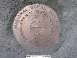
| Stamping:
|
8682 C 2015 |
| Stability:
|
Monument will probably hold position well |
| Setting:
|
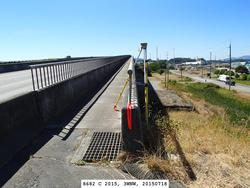
Abutment or pier of large bridges |
| Description:
|
The bench mark is a disk set in the concrete wing-wall at the east end of the west bound State Highway 20 Duane Berentson Bridge over the Swinomish Channel, 37.39 m (122.7 ft) WNW of a blue Bridge Maintained By sign, 3.88 m (12.7 ft) WNW of a rectangular metal electric utility cover in walkway, 2.59 m (8.5 ft) WNW of east end of concrete wall and metal railing for walkway on north side of bridge, and 2.37m (7.8 ft) NNE of center of concrete wall between roadway and walkway. |
| Observed:
|
2015-07-18T22:01:00Z |
| Source:
|
OPUS - page5 1209.04 |
|
|
|
| Close-up View
|
|
| REF_FRAME:
NAD_83(2011) |
EPOCH:
2010.0000 |
SOURCE:
NAVD88 (Computed using GEOID18) |
UNITS:
m |
SET PROFILE
|
DETAILS
|
|
| LAT:
|
48° 27' 14.21728"
|
± 0.002
m |
| LON:
|
-122° 30' 27.88485"
|
±
0.005
m |
| ELL HT:
|
-9.704 |
±
0.004
m |
| X:
|
-2277594.617 |
±
0.005
m |
| Y:
|
-3574041.084 |
±
0.001
m |
| Z:
|
4750495.662 |
±
0.004
m |
| ORTHO HT:
|
12.245 |
±
0.042
m |
|
|
UTM
10 |
SPC
4601(WA N) |
| NORTHING:
|
5366873.817m |
163003.337m |
| EASTING:
|
536396.602m |
376161.310m |
| CONVERGENCE:
|
0.36841835°
|
-1.24663411°
|
| POINT SCALE:
|
0.99961628 |
0.99995944 |
| COMBINED FACTOR:
|
0.99961780 |
0.99996096 |
|
|
|
|
| Horizon View
|
|
|
|
|