| PID:
|
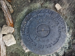
BBDX54 |
| Designation:
|
945 2421 E |
| Stamping:
|
2421 E 1998 |
| Stability:
|
May hold, commonly subject to ground movement |
| Setting:
|
Unspecified rock or boulder |
| Description:
|
From the NOAA website: The bench mark is a disk set on top of a low-lying flat 1 m x 1 m x 0.3 m (2 ft x 3 ft x 1 ft) rock located on the eastern bank of Chilkat Inlet, 235 m (771 ft) SE of Letnikof Cove Light F1 R 4 sec, on a boulder strewn section of beach just north of the prominent, dark-coloured, steep-faced, mussel-encrusted rocky ledge, 56 m (184 ft) NW (340 degrees magnetic) from bench mark 2421 D 1998, 15 m (49 ft) inland of the apparent high water line, and 10 m (33 ft) below treeline. |
| Observed:
|
2015-06-28T18:13:00Z |
| Source:
|
OPUS - page5 1209.04 |
|
|
|
| Close-up View
|
|