| PID:
|
BBDX53 |
| Designation:
|
944 9988 TIDAL 1 |
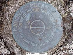
| Stamping:
|
BM 1 1974 |
| Stability:
|
Most reliable; expected to hold position well |
| Setting:
|
In rock outcrop or ledge |
| Description:
|
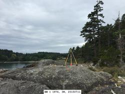
The bench mark is a disk set in the top of a rock outcrop near the NE point at the entrance to Telegraph Bay, 29.25 m (96.0 ft) east of bench mark 2 1974, 28.0 m (91.9 ft) NW of the eastern most extent of the rock point, 12.23 m (40.1 ft) SE of the nearest evergreen tree, 4.96 m (16.3 ft) SSW of the north end of the rock outcrop and 3.07 m (10.1 ft) SSE of the west side of the rock outcrop and inland grassy area. |
| Observed:
|
2015-07-11T23:28:00Z |
| Source:
|
OPUS - page5 1209.04 |
|
|
|
| Close-up View
|
|
| REF_FRAME:
NAD_83(2011) |
EPOCH:
2010.0000 |
SOURCE:
NAVD88 (Computed using GEOID18) |
UNITS:
m |
SET PROFILE
|
DETAILS
|
|
| LAT:
|
48° 26' 38.57516"
|
± 0.003
m |
| LON:
|
-122° 48' 14.82896"
|
±
0.004
m |
| ELL HT:
|
-15.840 |
±
0.007
m |
| X:
|
-2296495.633 |
±
0.004
m |
| Y:
|
-3562901.119 |
±
0.008
m |
| Z:
|
4749760.835 |
±
0.003
m |
| ORTHO HT:
|
5.951 |
±
0.053
m |
|
|
UTM
10 |
SPC
4601(WA N) |
| NORTHING:
|
5365674.834m |
162421.932m |
| EASTING:
|
514485.995m |
354217.929m |
| CONVERGENCE:
|
0.14657951°
|
-1.46729010°
|
| POINT SCALE:
|
0.99960258 |
0.99995844 |
| COMBINED FACTOR:
|
0.99960506 |
0.99996092 |
|
|
|
|
| Horizon View
|
|
|
|
|