| PID:
|
BBDV81 |
| Designation:
|
846 9198 C |
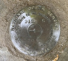
| Stamping:
|
9198 C 2015 |
| Stability:
|
Monument will probably hold position well |
| Setting:
|
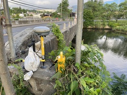
Retaining wall or concrete ledge |
| Mark Condition:
|
G |
| Description:
|
The bench mark is a disk set in the NE wing wall of the Pulaski street bridge over the Rippowam river, 29.50 m (96.8 ft) SSW of the SW corner of a parking garage building, 22.81 m (74.8 ft) W of the decorative light E of the Pulaski street bridge, 2.25 m (7.4 ft) N of the curb edge of Pulaski street, 1.21 m (4.0 ft) NNE of the E end of an aluminum guard rail, 0.50 m (1.6 ft) S from the N end of the parapet wall and about 0.70 m (2.3 ft) above the level of sidewalk. |
| Observed:
|
2022-06-23T10:41:00Z |
more obs 2022-07-15
|
| Source:
|
OPUS - page5 2008.25 |
|
|
|
| Close-up View
|
|
| REF_FRAME:
NAD_83(2011) |
EPOCH:
2010.0000 |
SOURCE:
NAVD88 (Computed using GEOID18) |
UNITS:
m |
SET PROFILE
|
DETAILS
|
|
| LAT:
|
41° 2' 38.89122"
|
± 0.022
m |
| LON:
|
-73° 32' 41.12995"
|
±
0.029
m |
| ELL HT:
|
-23.697 |
±
0.031
m |
| X:
|
1364594.361 |
±
0.028
m |
| Y:
|
-4620043.422 |
±
0.014
m |
| Z:
|
4166105.644 |
±
0.037
m |
| ORTHO HT:
|
6.756 |
±
0.069
m |
|
|
UTM
18 |
SPC
600(CT) |
| NORTHING:
|
4544676.682m |
176118.737m |
| EASTING:
|
622308.213m |
237977.742m |
| CONVERGENCE:
|
0.95568889°
|
-0.52697222°
|
| POINT SCALE:
|
0.99978411 |
1.00001940 |
| COMBINED FACTOR:
|
0.99978783 |
1.00002312 |
|
|
|
|
| Horizon View
|
|
|
|
|