| PID:
|
BBDV80 |
| Designation:
|
841 7087 A |
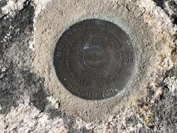
| Stamping:
|
7087 A 2015 |
| Stability:
|
Most reliable; expected to hold position well |
| Setting:
|
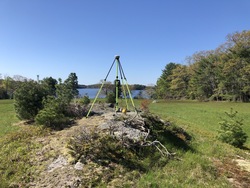
In rock outcrop or ledge |
| Mark Condition:
|
G |
| Description:
|
The primary bench mark is a disk set in bedrock, 172.3 ft NNE of a 4 ft by 4 ft lone boulder in a field, 151.6 ft NNW of the highest point of a bedrock outcrop E of the two track, 116.1 ft E of the approximate center of a grove of four white pine trees, 42.0 ft W of the W edge of the two track, 3.4 ft ENE of the highest point on the bedrock outcrop and about 4.3 ft higher than the two track grade. |
| Observed:
|
2021-05-14T13:07:00Z |
more obs 2021-07-21
|
| Source:
|
OPUS - page5 2008.25 |
|
|
|
| Close-up View
|
|
| REF_FRAME:
NAD_83(2011) |
EPOCH:
2010.0000 |
SOURCE:
NAVD88 (Computed using GEOID18) |
UNITS:
m |
SET PROFILE
|
DETAILS
|
|
| LAT:
|
43° 54' 1.74949"
|
± 0.011
m |
| LON:
|
-69° 44' 31.46230"
|
±
0.012
m |
| ELL HT:
|
-11.958 |
±
0.002
m |
| X:
|
1593823.365 |
±
0.008
m |
| Y:
|
-4318407.242 |
±
0.013
m |
| Z:
|
4400122.820 |
±
0.006
m |
| ORTHO HT:
|
13.740 |
±
0.060
m |
|
|
UTM
19 |
SPC
1802(ME W) |
| NORTHING:
|
4861087.742m |
118644.229m |
| EASTING:
|
440405.550m |
934110.797m |
| CONVERGENCE:
|
-0.51457500°
|
0.29441944°
|
| POINT SCALE:
|
0.99964368 |
0.99998097 |
| COMBINED FACTOR:
|
0.99964555 |
0.99998285 |
|
|
|
|
| Horizon View
|
|
|
|
|