| PID:
|
BBDV09 |
| Designation:
|
846 9057 D |
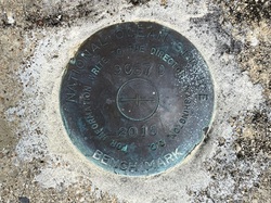
| Stamping:
|
9057 D 2015 |
| Stability:
|
Monument will probably hold position well |
| Setting:
|
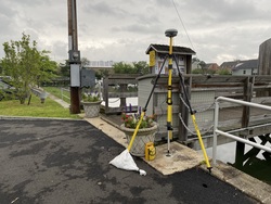
Massive structures (other than listed below) |
| Mark Condition:
|
G |
| Description:
|
The bench mark is a disk set in a concrete abutment at the base of the Cos Cob public pier, 44.84 m (147.1 ft) NE of a utility pole numbered 67129, 40.43 m (132.6 ft) ESE of a utility pole numbered 67128, 8.09 m (26.5 ft) NNE of the N end of a guardrail on the E side of the parking lot, 7.96 m (26.1 ft) W of the center of the wooden door to the pier and 4.43 m (14.5 ft) SSW of a unnumbered utility pole just north of the abutment. |
| Observed:
|
2022-06-22T11:46:00Z |
more obs 2022-07-12
|
| Source:
|
OPUS - page5 2008.25 |
|
|
|
| Close-up View
|
|
| REF_FRAME:
NAD_83(2011) |
EPOCH:
2010.0000 |
SOURCE:
NAVD88 (Computed using GEOID18) |
UNITS:
m |
SET PROFILE
|
DETAILS
|
|
| LAT:
|
41° 1' 56.49812"
|
± 0.008
m |
| LON:
|
-73° 35' 49.53858"
|
±
0.015
m |
| ELL HT:
|
-28.083 |
±
0.011
m |
| X:
|
1360615.235 |
±
0.014
m |
| Y:
|
-4622108.463 |
±
0.006
m |
| Z:
|
4165116.359 |
±
0.013
m |
| ORTHO HT:
|
2.476 |
±
0.054
m |
|
|
UTM
18 |
SPC
600(CT) |
| NORTHING:
|
4543297.329m |
174852.814m |
| EASTING:
|
617930.464m |
233564.697m |
| CONVERGENCE:
|
0.92109167°
|
-0.56167500°
|
| POINT SCALE:
|
0.99977117 |
1.00002117 |
| COMBINED FACTOR:
|
0.99977557 |
1.00002558 |
|
|
|
|
| Horizon View
|
|
|
|
|