| PID:
|
BBDV08 |
| Designation:
|
846 8191 A |
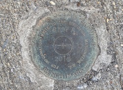
| Stamping:
|
8191 A 2015 |
| Stability:
|
Monument will probably hold position well |
| Setting:
|
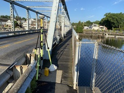
Abutment or pier of large bridges |
| Mark Condition:
|
G |
| Description:
|
The bench mark is a disk set in the NE concrete bridge abutment of the state highway 136 bridge over the Saugatuck River, 16.50 m (54.1 ft) W of the S drawbridge closure gate, 14.99 m (49.2 ft) WSW of the N drawbridge closure gate, 5.38 m (17.7 ft) E of the second guard rail post W of the NE bridge abutment, 3.53 m (11.6 ft) NNW of the intersection of the centerline of state highway 136 and the bridge abutment and 1.30 m (4.3 ft) S of a fence corner on the NW side of the bridge. |
| Observed:
|
2022-07-19T11:23:00Z |
more obs 2022-07-27
|
| Source:
|
OPUS - page5 2008.25 |
|
|
|
| Close-up View
|
|
| REF_FRAME:
NAD_83(2011) |
EPOCH:
2010.0000 |
SOURCE:
NAVD88 (Computed using GEOID18) |
UNITS:
m |
SET PROFILE
|
DETAILS
|
|
| LAT:
|
41° 7' 22.26983"
|
± 0.003
m |
| LON:
|
-73° 22' 7.57538"
|
±
0.003
m |
| ELL HT:
|
-26.501 |
±
0.019
m |
| X:
|
1377133.818 |
±
0.005
m |
| Y:
|
-4610323.727 |
±
0.014
m |
| Z:
|
4172692.988 |
±
0.012
m |
| ORTHO HT:
|
3.517 |
±
0.056
m |
|
|
UTM
18 |
SPC
600(CT) |
| NORTHING:
|
4553677.227m |
184739.486m |
| EASTING:
|
636936.349m |
252836.980m |
| CONVERGENCE:
|
1.07298611°
|
-0.41028056°
|
| POINT SCALE:
|
0.99983079 |
1.00000869 |
| COMBINED FACTOR:
|
0.99983495 |
1.00001285 |
|
|
|
|
| Horizon View
|
|
|
|
|