| PID:
|
BBDT12 |
| Designation:
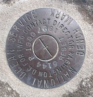
|
941 5144 P RESET |
| Stamping:
|
5144 P 1990 RESET 1997 |
| Stability:
|
Monument will probably hold position well |
| Setting:
|
Object surrounded by mass of concrete |
| Description:
|
The bench mark is a disk set flush in a concrete slab at the
head of the tug pier, 14.83 m (48.6 ft) east of the east side of a telephone
booth near the tug office, 3.81 m (12.5 ft) SE of the southern end of a guard
rail which leads to pier, and 0.49 m (1.6 ft) SW of the cut off base of an old flag pole flush with the concrete. |
| Observed:
|
2015-03-11T18:33:00Z |
| Source:
|
OPUS - page5 1209.04 |
|
|
|
| Close-up View
|
|