| PID:
|
BBDR24 |
| Designation:
|
876 1402 A |
| Stamping:
|
1402 A 2014 |
| Stability:
|
Monument will probably hold position well |
| Setting:
|
Abutment or pier of large bridges |
| Mark Condition:
|
G |
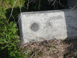
| Description:
|
The bench mark is set flush in the west wing wall of the abutment on the south side of the Highway 90 Bridge across The Rigolets, 188.8 Ft E of the seawall along the east side of channel of marina, 165.4 Ft NE of power pole, 105.5 Ft NNE of the south end of metal and wood highway guard rail, 32.2 Ft W of Centerline of highway at south edge of bridge concrete, and 3.1 Ft W of south end of all metal bridge guard rail. |
| Observed:
|
2018-02-27T15:38:00Z |
more obs 2018-02-28
|
| Source:
|
OPUS - page5 2008.25 |
|
|
|
| Close-up View
|
|
| REF_FRAME:
NAD_83(2011) |
EPOCH:
2010.0000 |
SOURCE:
NAVD88 (Computed using GEOID18) |
UNITS:
m |
SET PROFILE
|
DETAILS
|
|
| LAT:
|
30° 9' 54.34358"
|
± 0.001
m |
| LON:
|
-89° 44' 23.17189"
|
±
0.003
m |
| ELL HT:
|
-23.494 |
±
0.006
m |
| X:
|
25066.784 |
±
0.003
m |
| Y:
|
-5519005.848 |
±
0.005
m |
| Z:
|
3186198.255 |
±
0.004
m |
| ORTHO HT:
|
3.009 |
±
0.062
m |
|
|
UTM
16 |
SPC
1702(LA S) |
| NORTHING:
|
3340251.016m |
185633.810m |
| EASTING:
|
236143.876m |
1153486.140m |
| CONVERGENCE:
|
-1.37751389°
|
0.79680278°
|
| POINT SCALE:
|
1.00045901 |
0.99992984 |
| COMBINED FACTOR:
|
1.00046270 |
0.99993353 |
|
|
|
|
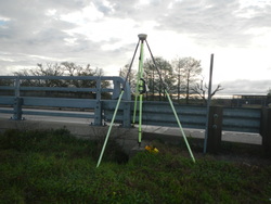
| Horizon View
|
|
|
|
|