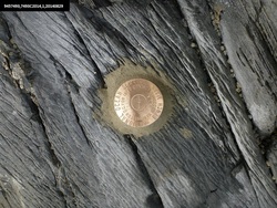
Shared Solution

PID: BBDR11
Designation: 945 7493 C
Stamping: 7493C 2014
Stability: May hold, commonly subject to ground movement
Setting: In rock outcrop or ledge
Description: The bench mark is a disk set flush in bedrock north of 026˚T (010˚M), 4m in front of a 16m vertical face, north of the small stream bisecting a small rocky beach. Benchmark 7493C 2014 is located 38.14 m (125.13 ft) NNE. However direct line of sight is blocked by a bedrock outcropping. When on the mark, the highest point on the Eastern shore.The prominent point on the western shore of Terror Bay towards the mudflats bears 140˚T (124˚M).
Observed: 2014-08-30T00:14:00Z
Source: OPUS - page5 1209.04
Close-up View
REF_FRAME:   NAD_83(2011) EPOCH:   2010.0000 SOURCE:   NAVD88 (Computed using GEOID12B) UNITS:  m  SET PROFILE   DETAILS
LAT: 57° 43' 54.27577" ±  0.040   m
LON: -153° 13' 22.71756" ±   0.024   m
ELL HT: 14.382 ±   0.038   m
X: -3047343.686 ±   0.040  m
Y: -1537790.482 ±   0.041  m
Z: 5369858.141 ±   0.022  m
ORTHO HT: 2.736 ±  0.065   m
UTM  5 SPC  5005(AK 5)
NORTHING: 6398866.788m 415713.313m
EASTING: 486721.594m 546285.460m
CONVERGENCE: -0.18854029° 0.65702928°
POINT SCALE: 0.99960216 0.99992626
COMBINED FACTOR: 0.99959991 0.99992401
CONTRIBUTED BY
thomas.l.burrow
National Oceanic and Atmospheric Administration
Horizon View
The numerical values for this position solution have satisfied the quality control criteria of the National Geodetic Survey. The contributor has verified that the information submitted is accurate and complete.