| PID:
|
BBDQ20 |
| Designation:
|
844 7368 E |
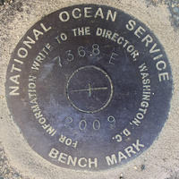
| Stamping:
|
7368 E 2009 |
| Stability:
|
|
| Setting:
|
Object surrounded by mass of concrete |
| Mark Condition:
|
G |
| Description:
|
The bench mark is set flush in the SE corner of a concrete dock near the paved road located on the property of the Great Hill Estate, 44.03 m (144.6 ft) SSE of bench mark 844 7368 D, 7.55 m (24.77 ft) SE of the SW corner of the dock, and 2.36 m (7.74 ft) north of the shore end of the dock. |
| Observed:
|
2021-05-25T11:44:00Z |
more obs 2021-06-14
|
| Source:
|
OPUS - page5 2008.25 |
|
|
|
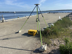
| Close-up View
|
|
| REF_FRAME:
NAD_83(2011) |
EPOCH:
2010.0000 |
SOURCE:
NAVD88 (Computed using GEOID18) |
UNITS:
m |
SET PROFILE
|
DETAILS
|
|
| LAT:
|
41° 42' 38.20579"
|
± 0.002
m |
| LON:
|
-70° 42' 55.59300"
|
±
0.002
m |
| ELL HT:
|
-27.334 |
±
0.012
m |
| X:
|
1574820.264 |
±
0.004
m |
| Y:
|
-4500869.233 |
±
0.010
m |
| Z:
|
4221644.991 |
±
0.006
m |
| ORTHO HT:
|
1.402 |
±
0.053
m |
|
|
UTM
19 |
SPC
2001(MA M) |
| NORTHING:
|
4619068.436m |
829227.716m |
| EASTING:
|
357286.778m |
265294.001m |
| CONVERGENCE:
|
-1.14159444°
|
0.52701111°
|
| POINT SCALE:
|
0.99985063 |
1.00000089 |
| COMBINED FACTOR:
|
0.99985492 |
1.00000518 |
|
|
|
|
| Horizon View
|
|
|
|
|