| PID:
|
BBDN51 |
| Designation:
|
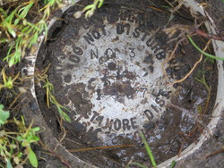
857 1117 TIDAL 3 |
| Stamping:
|
NO 3 1997 |
| Stability:
|
Monument will probably hold position well |
| Setting:
|
Set in top of concrete monument |
| Description:
|
From the intersection of Caleb Jones Road and Smith Island Road, Smith Island, Somerset County, Maryland, go Northerly on Smith Island Road 260 ft., turn right into a parking area, go to the Southwest corner of the parking, Stop. Monument "NO 3" is Southwest 83.4 ft. from the southeast corner of the Bayside Inn, Southeast 72.8 ft. from the southeast corner of the Bayside Gift Shop and North 15.5 ft. from the Southeast Property Corner of the Bayside Inn. |
| Observed:
|
2014-06-12T13:12:00Z |
| Source:
|
OPUS - page5 1209.04 |
|
|
|
| Close-up View
|
|