| PID:
|
BBDN11 |
| Designation:
|
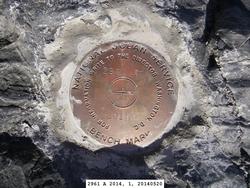
946 2961 A |
| Stamping:
|
2961 A 2014 |
| Stability:
|
Most reliable; expected to hold position well |
| Setting:
|
In rock outcrop or ledge |
| Description:
|
From the small boat harbor in False Pass, proceed south approximately 10.2 km (5.5 nm) through Isanotski Strait to Ikatan Bay, the bench mark is a disk set in a rock outcrop 3 m wide x 5 m long (10 ft wide x 16 ft long) below the high water line, 163 m (535 ft) SE of ruins remaining from the Johnson/Kristensen Cabin, 124 m (407 ft) NE of Bench Mark 946 2961 B, 46 m (151 ft) ENE of the 3 m (10 ft) high sand berm, and 0.5 m (1.6 ft) above the beach. |
| Observed:
|
2014-05-21T18:09:00Z |
| Source:
|
OPUS - page5 1209.04 |
|
|
|
| Close-up View
|
|
| REF_FRAME:
NAD_83(2011) |
EPOCH:
2010.0000 |
SOURCE:
NAVD88 (Computed using GEOID12B) |
UNITS:
m |
SET PROFILE
|
DETAILS
|
|
| LAT:
|
54° 46' 53.37021"
|
± 0.005
m |
| LON:
|
-163° 21' 48.12640"
|
±
0.014
m |
| ELL HT:
|
18.997 |
±
0.014
m |
| X:
|
-3532185.388 |
±
0.012
m |
| Y:
|
-1055449.634 |
±
0.012
m |
| Z:
|
5187409.023 |
±
0.012
m |
| ORTHO HT:
|
1.941 |
±
0.025
m |
|
|
UTM
3 |
SPC
5010(AK10) |
| NORTHING:
|
6071704.754m |
492131.873m |
| EASTING:
|
605256.312m |
1809228.304m |
| CONVERGENCE:
|
1.33718206°
|
10.07041461°
|
| POINT SCALE:
|
0.99973592 |
1.00043156 |
| COMBINED FACTOR:
|
0.99973295 |
1.00042858 |
|
|
|

|
| Horizon View
|
|
|
|
|