| PID:
|
BBDN10 |
| Designation:
|
946 2955 B |
| Stamping:
|
2955 B 2013 |
| Stability:
|
Monument will probably hold position well |
| Setting:
|
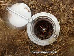
Stainless steel rod in sleeve (10FT+ or 3.048M+) |
| Mark Condition:
|
G |
| Description:
|
From the False Pass gravel airstrip, proceed NNW on Beach Rd for 0.5 km (0.3 mi), the bench mark is a SS rod set 48.85 m (160.3 ft) SSW of telephone box #3, 19.00 m (62.3 ft) SW of centerline of Beach Rd, 14.75 m (48.4 ft) SSE of centerline of a private gravel driveway, and 12.12 m (39.8 ft) NNW of alder vegetation line. The datum point is set 2 cm (0.1 ft) below grade, being the top of a SS rod driven 13.2 m (43.3 ft) to refusal, in a 0.9 m (3 ft) sleeve encased in a 5-inch NOS logo cover. |
| Observed:
|
2013-05-19T15:42:00Z |
more obs 2014-06-11
|
| Source:
|
OPUS - page5 1209.04 |
|
|
|
| Close-up View
|
|
| REF_FRAME:
NAD_83(2011) |
EPOCH:
2010.0000 |
SOURCE:
NAVD88 (Computed using GEOID12B) |
UNITS:
m |
SET PROFILE
|
DETAILS
|
|
| LAT:
|
54° 51' 13.99036"
|
± 0.006
m |
| LON:
|
-163° 24' 48.37969"
|
±
0.005
m |
| ELL HT:
|
22.501 |
±
0.005
m |
| X:
|
-3526795.605 |
±
0.008
m |
| Y:
|
-1050482.766 |
±
0.003
m |
| Z:
|
5192055.317 |
±
0.002
m |
| ORTHO HT:
|
5.654 |
±
0.011
m |
|
|
UTM
3 |
SPC
5010(AK10) |
| NORTHING:
|
6079685.451m |
499508.799m |
| EASTING:
|
601854.085m |
1804650.486m |
| CONVERGENCE:
|
1.29742056°
|
10.03051243°
|
| POINT SCALE:
|
0.99972727 |
1.00047622 |
| COMBINED FACTOR:
|
0.99972375 |
1.00047269 |
|
|
|
|
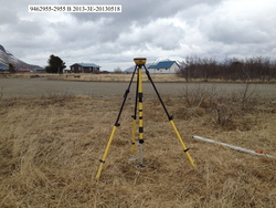
| Horizon View
|
|
|
|
|