| PID:
|
BBDM50 |
| Designation:
|
851 8902 B |
| Stamping:
|
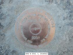
8902 B 2014 |
| Stability:
|
Most reliable; expected to hold position well |
| Setting:
|
In rock outcrop or ledge |
| Description:
|
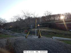
THE BENCH MARK IS SET IN A BEDROCK OUTCROP ON THE WEST SIDE OF THE PATH IN THE RIVER FRONT PARK NORTH OF DYCKMAN STREET, 35.85 M (117.6 FT) SSW OF THE NORTH END OF THE BEDROCK OUTCROP, 10.11 M (33.2 FT) WEST-SOUTHWEST OF A LAMP POST, 5.95 M (19.5 FT) WNW OF THE CENTERLINE OF THE PATH, 5.53 M (18.1 FT) NNE OF THE SOUTH END OF THE BEDROCK OUTCROP, 4.30 M (14.1 FT) WNW OF THE NW CORNER OF THE STONE CAPPED RETAINING WALL, AND 1.20 M (3.9 FT) ABOVE THE PATH. |
| Observed:
|
2014-04-12T11:42:00Z |
| Source:
|
OPUS - page5 1209.04 |
|
|
|
| Close-up View
|
|
| REF_FRAME:
NAD_83(2011) |
EPOCH:
2010.0000 |
SOURCE:
NAVD88 (Computed using GEOID18) |
UNITS:
m |
SET PROFILE
|
DETAILS
|
|
| LAT:
|
40° 52' 10.37710"
|
± 0.002
m |
| LON:
|
-73° 55' 53.47495"
|
±
0.006
m |
| ELL HT:
|
-26.532 |
±
0.015
m |
| X:
|
1336893.976 |
±
0.008
m |
| Y:
|
-4641359.801 |
±
0.011
m |
| Z:
|
4151461.622 |
±
0.009
m |
| ORTHO HT:
|
4.939 |
±
0.048
m |
|
|
UTM
18 |
SPC
3104(NY L ) |
| NORTHING:
|
4524825.327m |
78054.961m |
| EASTING:
|
590038.433m |
305772.823m |
| CONVERGENCE:
|
0.69919450°
|
0.04479101°
|
| POINT SCALE:
|
0.99969978 |
0.99999496 |
| COMBINED FACTOR:
|
0.99970394 |
0.99999912 |
|
|
|
|
| Horizon View
|
|
|
|
|