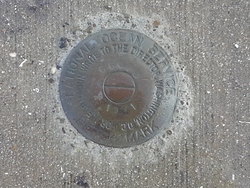
Shared Solution

PID: BBDM30
Designation: 872 6607 C
Stamping: 6607 C 1991
Stability:
Setting: Footings of small/medium structures
Description: Station is located in the Port Tampa ship basin, north of Picnic Island, South Tampa, Hillsborough Co., Florida. The bench mark is a disk set in the SW corner of a concrete base of a bollard along the south side of the Port Tampa ship basin, 156.5 ft NW of power pole No. 22230, 53.5 ft east of the centerline of the entrance ramp for the Chevron USA loading dock, and 29.9 ft north of the centerline of the access road. Mark is a standard NOS tidal benchmark.
Observed: 2014-03-31T13:49:00Z
Source: OPUS - page5 1209.04
Close-up View
REF_FRAME:   NAD_83(2011) EPOCH:   2010.0000 SOURCE:   NAVD88 (Computed using GEOID18) UNITS:  m  SET PROFILE   DETAILS
LAT: 27° 51' 38.69436" ±  0.006   m
LON: -82° 33'  3.12162" ±   0.004   m
ELL HT: -23.630 ±   0.015   m
X: 731582.581 ±   0.003  m
Y: -5595302.833 ±   0.014  m
Z: 2962860.127 ±   0.008  m
ORTHO HT: 1.162 ±  0.052   m
UTM  17 SPC  902(FL W)
NORTHING: 3082742.798m 390900.147m
EASTING: 347308.683m 145748.904m
CONVERGENCE: -0.72489840° -0.25743987°
POINT SCALE: 0.99988777 0.99997749
COMBINED FACTOR: 0.99989148 0.99998120
CONTRIBUTED BY
francis.m.woodward
US Army Corps Of Engineers
Horizon View
The numerical values for this position solution have satisfied the quality control criteria of the National Geodetic Survey. The contributor has verified that the information submitted is accurate and complete.