| PID:
|
BBDM15 |
| Designation:
|
857 2770 NO TIDAL 2 |
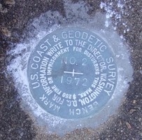
| Stamping:
|
NO 2 1972 |
| Stability:
|
Most reliable; expected to hold position well |
| Setting:
|
Pavement (street, sidewalk, curb, etc.) |
| Mark Condition:
|
G |
| Description:
|
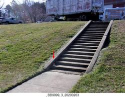
The bench mark is a disk set flush in the second concrete step leading from the abandoned ferry landing to the warehouse, 13.11 m (43.0 ft) NE of the flagpole on the police facilities grounds, 12.5 m (40.9 ft) SW of the SW curbing surrounding police boats and the warehouse, 1.71 m (5.6 ft) SE of the most NW point of the stairs leading to the warehouse, and 0.1 m (0.3 ft) above the sidewalk. |
| Observed:
|
2020-03-09T15:55:00Z |
more obs 2020-04-15
|
| Source:
|
OPUS - page5 1801.18 |
|
|
|
| Close-up View
|
|
| REF_FRAME:
NAD_83(2011) |
EPOCH:
2010.0000 |
SOURCE:
NAVD88 (Computed using GEOID18) |
UNITS:
m |
SET PROFILE
|
DETAILS
|
|
| LAT:
|
38° 57' 19.16370"
|
± 0.002
m |
| LON:
|
-76° 21' 15.44569"
|
±
0.004
m |
| ELL HT:
|
-31.169 |
±
0.005
m |
| X:
|
1171665.830 |
±
0.005
m |
| Y:
|
-4826236.169 |
±
0.004
m |
| Z:
|
3988441.728 |
±
0.002
m |
| ORTHO HT:
|
2.419 |
±
0.052
m |
|
|
UTM
18 |
SPC
1900(MD) |
| NORTHING:
|
4312690.797m |
143244.595m |
| EASTING:
|
382653.586m |
455967.434m |
| CONVERGENCE:
|
-0.85155833°
|
0.40526944°
|
| POINT SCALE:
|
0.99976956 |
0.99995081 |
| COMBINED FACTOR:
|
0.99977445 |
0.99995570 |
|
|
|
|
| Horizon View
|
|
|
|
|