| PID:
|
BBDL40 |
| Designation:
|
863 8445 B |
| Stamping:
|
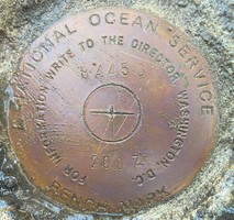
8445 B 2007 |
| Stability:
|
Most reliable; expected to hold position well |
| Setting:
|
Object surrounded by mass of concrete |
| Mark Condition:
|
G |
| Description:
|
The bench mark is a disk set flush in the top of the SW corner of the concrete boat ramp next to the westerly most 8 in diameter wood piling on the south side of the concrete ramp at the Colonial Harbor Marina , 83.99 m (275.6ft) WSW of bench mark 863 8445 A, 77.10 m (253.0ft) east of bench mark 863 8445 C, 52.32m (171.7ft) east of the NE corner of the 25.0 m x 10.5 m (82.0ftx34.4ft) metal shop building which is open on the west side, 6.21m (20.4ft) S of the NW corner of the concrete boat ramp |
| Observed:
|
2021-02-04T13:35:00Z |
more obs 2021-02-19
|
| Source:
|
OPUS - page5 2008.25 |
|
|
|
| Close-up View
|
|
| REF_FRAME:
NAD_83(2011) |
EPOCH:
2010.0000 |
SOURCE:
NAVD88 (Computed using GEOID18) |
UNITS:
m |
SET PROFILE
|
DETAILS
|
|
| LAT:
|
37° 24' 5.16197"
|
± 0.002
m |
| LON:
|
-76° 54' 50.72663"
|
±
0.005
m |
| ELL HT:
|
-33.991 |
±
0.012
m |
| X:
|
1148593.663 |
±
0.003
m |
| Y:
|
-4941291.737 |
±
0.011
m |
| Z:
|
3852858.864 |
±
0.006
m |
| ORTHO HT:
|
0.631 |
±
0.054
m |
|
|
UTM
18 |
SPC
4502(VA S) |
| NORTHING:
|
4141125.466m |
1119711.725m |
| EASTING:
|
330582.900m |
3640404.610m |
| CONVERGENCE:
|
-1.16288611°
|
0.96252778°
|
| POINT SCALE:
|
0.99995356 |
0.99994558 |
| COMBINED FACTOR:
|
0.99995889 |
0.99995091 |
|
|
|

|
| Horizon View
|
|
|
|
|