| PID:
|
BBDL27 |
| Designation:
|
863 8433 B |
| Stamping:
|
8433 B 2003 |
| Stability:
|
Most reliable; expected to hold position well |
| Setting:
|
A metal rod driven into ground. Describe below. |
| Mark Condition:
|
G |
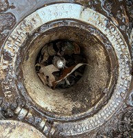
| Description:
|
The bench mark is a flange-encased rod located at the NE corner of a triangular shaped Virginia Department of Transportation (VDOT) commuter parking lot formed by the intersection of Route 31 (Rolfe Highway) with Short Drive, 47 m (154 ft) NNE of Virginia power pole number BK91, 23.5 m (77.1 ft) SSW of the centerline of the intersection of Rolfe Highway and Short Drive, and 2.2 m (7.2 ft) south of the Surry County welcome sign. The datum point is set 10 cm (.3 ft) below the ground, being the top |
| Observed:
|
2021-01-27T15:35:00Z |
more obs 2021-02-11
|
| Source:
|
OPUS - page5 2008.25 |
|
|
|
| Close-up View
|
|
| REF_FRAME:
NAD_83(2011) |
EPOCH:
2010.0000 |
SOURCE:
NAVD88 (Computed using GEOID18) |
UNITS:
m |
SET PROFILE
|
DETAILS
|
|
| LAT:
|
37° 10' 51.85319"
|
± 0.017
m |
| LON:
|
-76° 47' 16.22882"
|
±
0.005
m |
| ELL HT:
|
-16.371 |
±
0.013
m |
| X:
|
1162868.673 |
±
0.005
m |
| Y:
|
-4953187.688 |
±
0.018
m |
| Z:
|
3833412.764 |
±
0.008
m |
| ORTHO HT:
|
18.843 |
±
0.058
m |
|
|
UTM
18 |
SPC
4502(VA S) |
| NORTHING:
|
4116456.059m |
1095455.655m |
| EASTING:
|
341295.902m |
3652024.124m |
| CONVERGENCE:
|
-1.08068333°
|
1.03915278°
|
| POINT SCALE:
|
0.99991027 |
0.99995067 |
| COMBINED FACTOR:
|
0.99991284 |
0.99995324 |
|
|
|
|
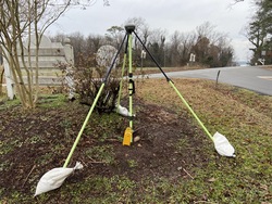
| Horizon View
|
|
|
|
|