| PID:
|
BBDL24 |
| Designation:
|
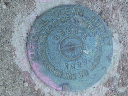
853 4883 E TIDAL |
| Stamping:
|
4883 E 1977 |
| Stability:
|
May hold, commonly subject to ground movement |
| Setting:
|
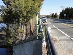
Abutment or pier of large bridges |
| Description:
|
The bench mark is located at Tuckahoe. Set in the north end of the Highway 50 bridge over the Tuckahoe River. The disk is set diagonally across the bridge from bench mark 4883 D 1977 and about 0.3 m (1 ft) below the level of the bridge, 0.98 m (3.2 ft) west of the west curb of the Highway bridge, 3.26 m (10.7ft) south of wood utility pole# 9, and 9.39 m (30.8 ft) north of the north steel gate post of the drawbridge. |
| Observed:
|
2014-04-09T13:23:00Z |
| Source:
|
OPUS - page5 1209.04 |
|
|
|
| Close-up View
|
|
| REF_FRAME:
NAD_83(2011) |
EPOCH:
2010.0000 |
SOURCE:
NAVD88 (Computed using GEOID18) |
UNITS:
m |
SET PROFILE
|
DETAILS
|
|
| LAT:
|
39° 17' 42.87843"
|
± 0.009
m |
| LON:
|
-74° 45' 8.23585"
|
±
0.012
m |
| ELL HT:
|
-30.145 |
±
0.009
m |
| X:
|
1299870.552 |
±
0.009
m |
| Y:
|
-4768620.276 |
±
0.015
m |
| Z:
|
4017717.564 |
±
0.004
m |
| ORTHO HT:
|
4.259 |
±
0.053
m |
|
|
UTM
18 |
SPC
2900(NJ ) |
| NORTHING:
|
4349570.203m |
51305.018m |
| EASTING:
|
521360.424m |
128238.500m |
| CONVERGENCE:
|
0.15688089°
|
-0.15977865°
|
| POINT SCALE:
|
0.99960562 |
0.99990583 |
| COMBINED FACTOR:
|
0.99961035 |
0.99991056 |
|
|
|
|
| Horizon View
|
|
|
|
|