| PID:
|
BBDL21 |
| Designation:
|
863 7712 D |
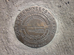
| Stamping:
|
7712 D 2010 |
| Stability:
|
Most reliable; expected to hold position well |
| Setting:
|
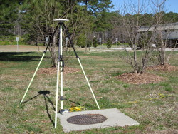
Object surrounded by mass of concrete |
| Description:
|
UPDATE Oct 2020: Mark reported destroyed.
This bench mark is a disk set in the west corner of a 4.9 ft. X 4.9 ft. concrete pad of a manhole. It is 144.4 ft Northeast of power pole No. 439D3, 56.6 ft. Southeast of a 3 ft. pine tree, and 24.1 f.t Northwest of the center line of Virginia Route 31. 95.8 ft. Northeast of a sign SOUTH 31. It is a standard U.S. Army Corps Of Engineers brass disk stamped 7712 D 2010, mounted flush with the concrete pad. |
| Observed:
|
2014-03-31T13:28:00Z |
| Source:
|
OPUS - page5 1209.04 |
|
|
|
| Close-up View
|
|
| REF_FRAME:
NAD_83(2011) |
EPOCH:
2010.0000 |
SOURCE:
NAVD88 (Computed using GEOID18) |
UNITS:
m |
SET PROFILE
|
DETAILS
|
|
| LAT:
|
37° 13' 37.14910"
|
± 0.004
m |
| LON:
|
-76° 47' 2.85261"
|
±
0.006
m |
| ELL HT:
|
-27.998 |
±
0.009
m |
| X:
|
1162483.346 |
±
0.005
m |
| Y:
|
-4950103.679 |
±
0.005
m |
| Z:
|
3837464.438 |
±
0.009
m |
| ORTHO HT:
|
7.179 |
±
0.053
m |
|
|
UTM
18 |
SPC
4502(VA S) |
| NORTHING:
|
4121544.248m |
1100556.319m |
| EASTING:
|
341721.711m |
3652261.390m |
| CONVERGENCE:
|
-1.07957410°
|
1.04140673°
|
| POINT SCALE:
|
0.99990861 |
0.99994839 |
| COMBINED FACTOR:
|
0.99991300 |
0.99995278 |
|
|
|
|
| Horizon View
|
|
|
|
|