| PID:
|
BBDL16 |
| Designation:
|
863 0249 A |
| Stamping:
|
0249 A 1982 |
| Stability:
|
Most reliable; expected to hold position well |
| Setting:
|
Retaining wall or concrete ledge |
| Mark Condition:
|
G |
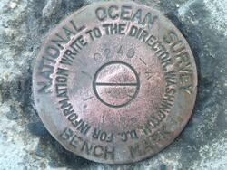
| Description:
|
The bench mark is a disk set in the concrete seawall at the U.S. Coast Guard Base, next to the boat ramp. 2.6 m (8.53 ft) SE of SE corner of boat ramp, 0.60 m (1.97 ft) NW of the SE corner of the seawall, 0.48 m (1.59 ft) west of the east edge of the seawall, and 0.39 m (1.29 ft) SE of the inside corner of the seawall |
| Observed:
|
2021-11-15T13:01:00Z |
more obs 2021-12-09
|
| Source:
|
OPUS - page5 2008.25 |
|
|
|
| Close-up View
|
|
| REF_FRAME:
NAD_83(2011) |
EPOCH:
2010.0000 |
SOURCE:
NAVD88 (Computed using GEOID18) |
UNITS:
m |
SET PROFILE
|
DETAILS
|
|
| LAT:
|
37° 55' 53.72440"
|
± 0.010
m |
| LON:
|
-75° 22' 57.90662"
|
±
0.001
m |
| ELL HT:
|
-35.850 |
±
0.034
m |
| X:
|
1271158.912 |
±
0.008
m |
| Y:
|
-4874038.632 |
±
0.032
m |
| Z:
|
3899435.608 |
±
0.013
m |
| ORTHO HT:
|
0.698 |
±
0.074
m |
|
|
UTM
18 |
SPC
4502(VA S) |
| NORTHING:
|
4198293.908m |
1181896.470m |
| EASTING:
|
466364.156m |
3773998.223m |
| CONVERGENCE:
|
-0.23528611°
|
1.89193611°
|
| POINT SCALE:
|
0.99961393 |
0.99999379 |
| COMBINED FACTOR:
|
0.99961955 |
0.99999942 |
|
|
|
|
| Horizon View
|
|
|
|
|