| PID:
|
BBDK07 |
| Designation:
|
851 6891 B |
| Stamping:
|
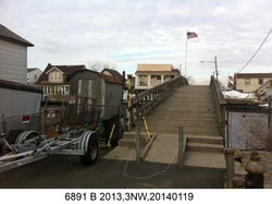
6891 B 2013 |
| Stability:
|
Monument will probably hold position well |
| Setting:
|
Footings of small/medium structures |
| Description:
|
The bench mark is a disk set in the top concrete step on the east side of the Meyer Avenue footbridge over Hook Creek, 29.73 m (97.5 ft) WNW of the center of the intersection of Meyer Avenue and First Street, 5.22 m (17.1 ft) ESE of the eastern most bridge piling on the south side of the bridge, 1.40 m (4.6 ft) SSW of the center line of the bridge, 0.18 m (0.6 ft) ESE of the western edge of the step, 0.17 m (0.6 ft) NNE of the southern edge of the step, and 0.46 m (1.5 ft) above the road. |
| Observed:
|
2014-01-19T14:03:00Z |
| Source:
|
OPUS - page5 1209.04 |
|
|

|
| Close-up View
|
|
| REF_FRAME:
NAD_83(2011) |
EPOCH:
2010.0000 |
SOURCE:
NAVD88 (Computed using GEOID18) |
UNITS:
m |
SET PROFILE
|
DETAILS
|
|
| LAT:
|
40° 38' 10.48239"
|
± 0.001
m |
| LON:
|
-73° 44' 30.62768"
|
±
0.003
m |
| ELL HT:
|
-30.132 |
±
0.025
m |
| X:
|
1356986.241 |
±
0.005
m |
| Y:
|
-4653142.326 |
±
0.018
m |
| Z:
|
4131833.070 |
±
0.017
m |
| ORTHO HT:
|
1.818 |
±
0.056
m |
|
|
UTM
18 |
SPC
3104(NY L ) |
| NORTHING:
|
4499138.927m |
52176.746m |
| EASTING:
|
606394.000m |
321839.234m |
| CONVERGENCE:
|
0.81945830°
|
0.16885716°
|
| POINT SCALE:
|
0.99973933 |
1.00000183 |
| COMBINED FACTOR:
|
0.99974406 |
1.00000656 |
|
|
|
|
| Horizon View
|
|
|
|
|