| PID:
|
BBDJ93 |
| Designation:
|
941 5584 F TIDAL |
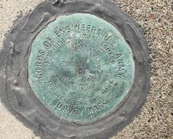
| Stamping:
|
5584 F 2014 |
| Stability:
|
Monument will probably hold position well |
| Setting:
|
Massive structures (other than listed below) |
| Mark Condition:
|
G |
| Description:
|
The benchmark is located 20.99 m east of the the east corner of the Harbor Masters Office (781 Baywood Dr.), 14.15 m (46.4 ft) SW of the south corner of the building at 775 Baywood Dr, and 12.87 m (42.2 ft) SE of a fuel tank. The bench mark is a disk set in the concrete walkway structure accessing the fueling dock on the NE side of the boat ramp, approximately 0.9 meter (3 ft) above ground. |
| Observed:
|
2022-03-13T18:03:00Z |
more obs 2022-05-05
|
| Source:
|
OPUS - page5 2008.25 |
|
|
|
| Close-up View
|
|
| REF_FRAME:
NAD_83(2011) |
EPOCH:
2010.0000 |
SOURCE:
NAVD88 (Computed using GEOID18) |
UNITS:
m |
SET PROFILE
|
DETAILS
|
|
| LAT:
|
38° 13' 52.23130"
|
± 0.008
m |
| LON:
|
-122° 36' 53.32993"
|
±
0.005
m |
| ELL HT:
|
-28.983 |
±
0.002
m |
| X:
|
-2703872.793 |
±
0.003
m |
| Y:
|
-4225520.650 |
±
0.007
m |
| Z:
|
3925614.586 |
±
0.005
m |
| ORTHO HT:
|
2.732 |
±
0.053
m |
|
|
UTM
10 |
SPC
402(CA 2) |
| NORTHING:
|
4231535.039m |
562847.122m |
| EASTING:
|
533711.936m |
1946168.422m |
| CONVERGENCE:
|
0.23836944°
|
-0.38761944°
|
| POINT SCALE:
|
0.99961400 |
1.00002473 |
| COMBINED FACTOR:
|
0.99961855 |
1.00002928 |
|
|
|
|
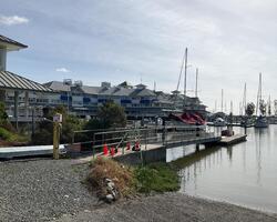
| Horizon View
|
|
|
|
|