| PID:
|
BBDJ16 |
| Designation:
|
846 1490 B |
| Stamping:
|
1490 B 1998 |
| Stability:
|
Most reliable; expected to hold position well |
| Setting:
|
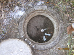
A metal rod driven into ground. Describe below. |
| Description:
|
The bench mark is located along the south side of the entrance road at the NE corner of the Connecticut pier property, 11.65 m (38.2 ft) north of the SE corner of a 2 door garage, 8.35 m (27.4 ft) NE of the NE corner of the garage, 2.11 m (6.9 ft) north of the last of four light poles in a row, and 0.95 m (3.1 ft) north of a NOAA witness post. |
| Observed:
|
2013-12-12T13:19:00Z |
| Source:
|
OPUS - page5 1209.04 |
|
|
|
| Close-up View
|
|
| REF_FRAME:
NAD_83(2011) |
EPOCH:
2010.0000 |
SOURCE:
NAVD88 (Computed using GEOID18) |
UNITS:
m |
SET PROFILE
|
DETAILS
|
|
| LAT:
|
41° 21' 43.75129"
|
± 0.007
m |
| LON:
|
-72° 5' 23.03431"
|
±
0.003
m |
| ELL HT:
|
-27.155 |
±
0.013
m |
| X:
|
1474312.331 |
±
0.005
m |
| Y:
|
-4561763.474 |
±
0.014
m |
| Z:
|
4192675.922 |
±
0.003
m |
| ORTHO HT:
|
3.411 |
±
0.054
m |
|
|
UTM
18 |
SPC
600(CT ) |
| NORTHING:
|
4583047.998m |
211340.782m |
| EASTING:
|
743426.860m |
360046.000m |
| CONVERGENCE:
|
1.92409516°
|
0.43779711°
|
| POINT SCALE:
|
1.00032932 |
0.99998760 |
| COMBINED FACTOR:
|
1.00033358 |
0.99999186 |
|
|
|
|
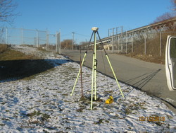
| Horizon View
|
|
|
|
|